
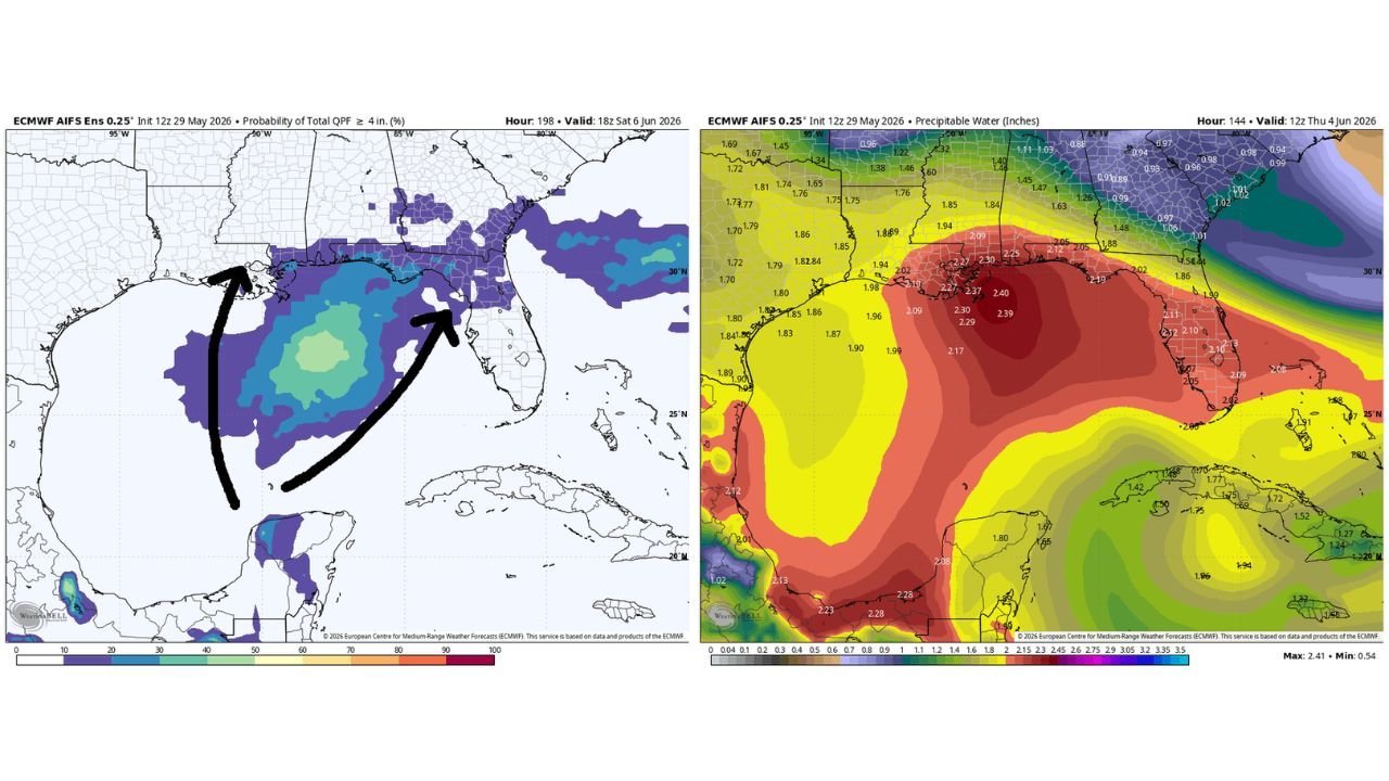
NEW ORLEANS, LOUISIANA — A significant surge of tropical moisture building in the Gulf of Mexico next week is expected to lift northward and produce heavy rainfall accumulations across Louisiana, Mississippi, Alabama, and Florida, with the Euro AI ensemble model initialized at 12z May 29, 2026 showing a meaningful probability of 4 inches or more of total rainfall across the impacted corridor as the moisture moves onshore Thursday June 4 into Friday June 5.
Euro AI Ensemble Shows 4 Inch Plus Rain Probability Covering Gulf Coast and Southeast Corridor
The left panel of the Euro AI ensemble output, showing the probability of total QPF reaching 4 inches or greater, displays a broad zone of elevated probability covering the Gulf Coast from Louisiana eastward through Mississippi, Alabama, and into Florida and Georgia. The purple and blue shading on the probability map covers a wide multi-state footprint, with the highest probability values concentrated along the immediate Gulf Coast zone where the tropical moisture surge is expected to make its most direct landfall-like push northward.
Two annotated arrows on the probability map trace the projected path of the moisture surge northward from the Gulf, indicating the trajectory forecasters are watching most closely as the June 4 to 5 timeframe approaches and the system begins its northward progression toward the coast.
Precipitable Water Values of 2.30 to 2.40 Inches Visible Across the Gulf in Euro AI Output
The right panel showing precipitable water values in the Euro AI model initialized at 12z May 29, 2026 reveals a deep red core of extremely high moisture content positioned over the Gulf of Mexico, with precipitable water values reaching 2.37 to 2.40 inches in the most saturated portions of the Gulf moisture pool. These values represent an exceptionally deep and juicy moisture reservoir available to be tapped by any organized convective system or weak tropical or hybrid system that develops within or along the edges of this moisture plume.
Values of 2.09 to 2.30 inches extend across a broader area of the central and eastern Gulf, with the moisture gradient running from the deep red core southward into the Caribbean and northward toward the Gulf Coast states.
Weak Tropical or Hybrid System Could Enhance Rainfall Totals Across the Region
Forecasters note that a weak tropical or hybrid system could form within or interact with this Gulf moisture plume, potentially enhancing the rainfall totals across Louisiana, Mississippi, Alabama, and Florida beyond what the moisture surge alone would produce. The Euro AI model is specifically lifting this tropical moisture toward the four-state corridor during the June 4 to 5 window, making the evolution of any organized circulation within the Gulf worth monitoring closely through next week.
Residents across the Gulf Coast and Florida should begin monitoring forecast updates as the June 4 to 5 timeframe approaches and the tropical moisture surge comes into sharper forecast focus.
Stay with GordonRamsayClub.com for the latest updates.

Leave a Reply