
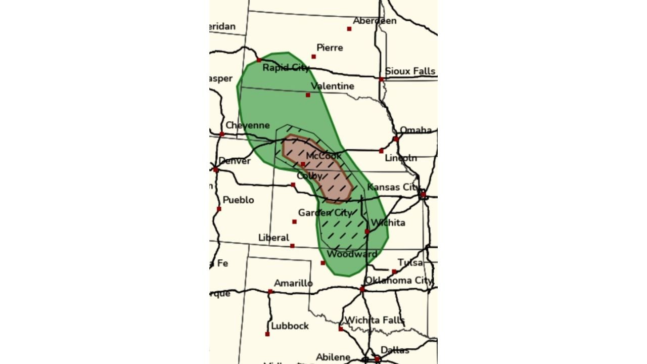
COLBY, KANSAS — Forecaster confidence in severe storm initiation across the northwest Kansas and southwest Nebraska corridor is facing serious questions Saturday May 30, 2026, with multiple model solutions trending downward on storm initiation before 8 PM and the SPC outlook map showing a tornado probability zone centered over McCook and Colby that meteorologists are actively debating as the afternoon setup evolves.
SPC Outlook Shows Tornado Probability Zone Centered Over McCook, Colby and Garden City Corridor
The SPC outlook map shows a hatched brown tornado probability zone centered across a focused corridor covering McCook and Colby in Kansas and Nebraska, with Garden City and Woodward sitting along the southern end of the outlined area. A broader green severe weather zone encompasses Rapid City, Valentine, Cheyenne, and extends southward through Wichita and toward Woodward, Oklahoma, covering a wide north-to-south corridor across the central plains within the overall severe weather threat footprint for today.
The hatched designation within the brown core indicates a higher-end tornado threat within that specific zone if storm initiation does occur, but the increasingly uncertain initiation timing is the central forecasting challenge heading into the late afternoon hours across northwest Kansas and southwest Nebraska.
Model Trends Showing Downward Initiation Signal Before 8 PM Raising Serious Doubts
All model solutions are trending toward delayed or suppressed storm initiation before 8 PM across the northern end of the SPC outlook zone, raising serious doubts among forecasters about whether the setup will deliver organized severe convection during the primary late afternoon window. The forecasting discussion notes significant surprise at lower tornado probabilities despite higher confidence in eventual storm initiation, with the subtropical jet stream trending toward hanging around longer and potentially initiating storms in western and southwest Oklahoma instead.
The SPC has noted that the decaying upper low and southward-shifting left exit region of the 300 mb jet streak may still provide enough forcing to get northwest Kansas and southwest Nebraska to fire, but trending model data is pointing against that scenario materializing before the evening hours.
HREF Ensemble Paintball Shows Scattered and Disagreeing Model Solutions Across the Plains
The NOAA NWS Storm Prediction Center HREF ensemble paintball map, run Saturday May 30, 2026 00:00 UTC and valid Sunday May 31, 2026 01:00 UTC, shows a highly scattered and disaggregated set of model solutions across the central and southern plains. The wide variety of colors representing different ensemble members across the Kansas, Nebraska, and Oklahoma corridor reflects the significant model spread and lack of consensus on exactly where, when, and how strongly convection will initiate across the outlook area through the evening hours.
Residents across northwest Kansas, southwest Nebraska, and adjacent areas should remain weather-aware through the evening hours as the setup continues to evolve.
Stay with GordonRamsayClub.com for the latest updates.

Leave a Reply