
UNITED STATES — A powerful squall line is forecast to push through Friday evening between 8 and 11 PM, bringing the potential for strong to severe thunderstorms with very strong winds as the primary danger, while much colder air moves in behind the system for the weekend with frost possible Saturday and Sunday night.
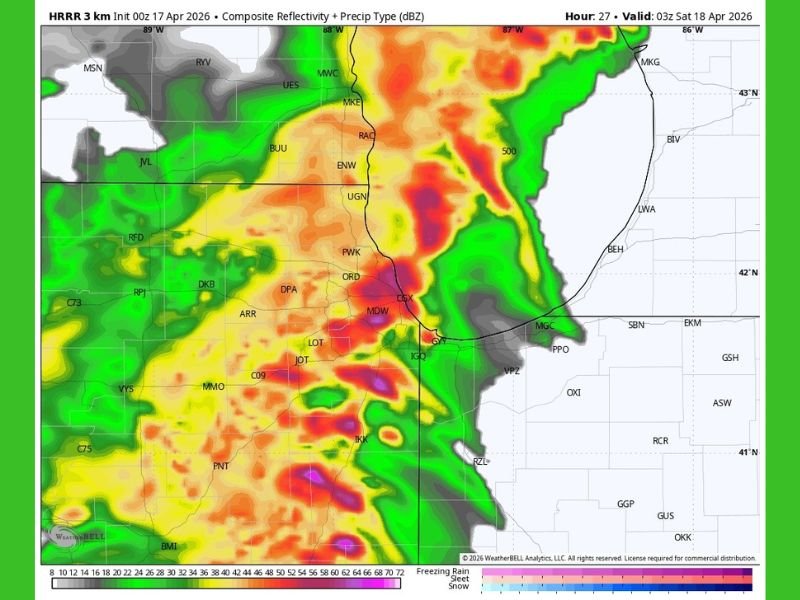
HRRR Models Show Intense Squall Line Pushing Through Between 8 and 11 PM Friday
The main forecast model currently in range, the HRRR, is showing a strong and intense squall line plowing through the region Friday evening between 8 and 11 PM. Models are insisting this powerful line of storms will punch straight through a stout atmospheric cap that is expected to be in place during the day and into the evening hours.
The cap is expected to suppress storm development through the daytime hours on Friday, but models remain firm that the squall line will break through regardless. Meteorologists have noted some uncertainty over whether the cap will hold or allow the storms to develop as forcefully as the HRRR currently suggests, with the final outcome depending heavily on how the cap responds to the incoming system.
Very Strong Winds Identified as the Primary Danger With Tornado Risk Remaining Low
If the squall line develops as shown by current models, very strong winds are forecast to be the dominant and most significant threat with this system. Damaging straight-line winds capable of downing trees, power lines, and causing structural damage would be the primary concern for residents in the path of the squall line Friday night.
The tornado threat for this particular area is assessed as quite low due to a fairly weak backed wind flow that does not support significant tornado development. Forecasters note that tornado risk looks considerably higher further out in Iowa, where atmospheric conditions are more favourable for rotating storms compared to the current local setup.
Cap Uncertainty Raises Questions Over Squall Line Strength and Coverage
One of the key uncertainties heading into Friday evening is whether the atmospheric cap will hold firm or break down sufficiently to allow the squall line to punch through at full intensity. Meteorologists have expressed some doubt over the models’ confidence in the cap breaking cleanly, which could affect how organised and intense the squall line ultimately becomes as it moves through the region between 8 and 11 PM.
Residents should monitor updated forecasts throughout Friday as conditions evolve and models receive new data that could shift the intensity and track of the approaching storm system in either direction.
Much Colder Air and Possible Frost Arrive Saturday and Sunday Night Behind System
Following the passage of the Friday evening storm system, a significant change in conditions is expected for the weekend. Much colder air is set to move into the region, bringing temperatures down sharply from the levels seen ahead of the storm system.
Frost is possible both Saturday night and Sunday night as the cold air settles in behind the departing system, meaning residents should prepare for a dramatic temperature swing between the stormy Friday evening and the cold weekend conditions that follow shortly after. Stay with GordonRamsayClub.com for the latest weather updates and detailed forecast coverage.

Leave a Reply