
ABERDEEN, SOUTH DAKOTA — The Storm Prediction Center has outlined a Slight Risk Level 2 of 5 across the eastern Dakotas, far northern Nebraska, and far western Minnesota for today June 3, 2026, as a dangerous severe weather setup featuring all-hazards supercells transitioning into a robust MCS with damaging winds and embedded tornado potential is expected to develop this afternoon and evening.
SPC Slight Risk Covers Eastern Dakotas as Cold Front and Shortwave Trough Approach
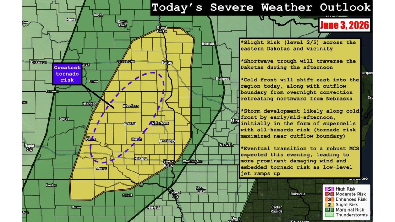
Today’s severe weather outlook covering June 3, 2026 shows a well-defined Slight Risk zone stretching from the Fargo and Grand Forks corridor in the north southward through Jamestown, Aberdeen, Huron, Watertown, Pierre, and Sioux Falls and into far northern Nebraska near O’Neill and Norfolk. A shortwave trough will traverse the Dakotas during the afternoon while a cold front shifts eastward into the region, combining with an outflow boundary retreating northward from Nebraska to create a highly favorable environment for storm initiation by early to mid-afternoon.
Supercells with All-Hazards Risk Expected to Develop by Early to Mid-Afternoon
Storm development is anticipated along the cold front by early to mid-afternoon, initially in the form of supercells carrying an all-hazards risk including large hail, damaging winds, and tornadoes. The greatest tornado risk is specifically highlighted near the subtle northward-retreating outflow boundary across central and eastern South Dakota, where the interaction of the cold front and outflow boundary will maximize low-level wind shear and tornado potential during the afternoon hours. The dashed purple circle on the outlook map highlights this zone of maximized tornado potential centered near Aberdeen, Huron, Redfield, and Watertown.
Robust MCS Expected to Develop This Evening with Damaging Winds and Embedded Tornadoes
As the afternoon progresses, the initial supercell mode is expected to transition into a robust and organized MCS by this evening. The MCS transition will bring a shift in primary hazards toward more prominent damaging wind gusts and embedded tornado potential as low-level jet stream winds ramp up through the evening hours. This evolution from discrete supercells to an organized convective system means the severe weather threat will persist and potentially intensify well into the overnight hours across the eastern Dakotas and surrounding region.
Residents Across Eastern South Dakota and Surrounding Areas Should Act Now
With all severe hazards possible from early afternoon through the overnight hours, residents across Fargo, Aberdeen, Huron, Sioux Falls, Pierre, Watertown, and surrounding communities should have shelter plans ready, stay closely connected to local NWS updates, and be prepared to act immediately when warnings are issued today.
Stay with GordonRamsayClub.com for the latest updates.

Leave a Reply