
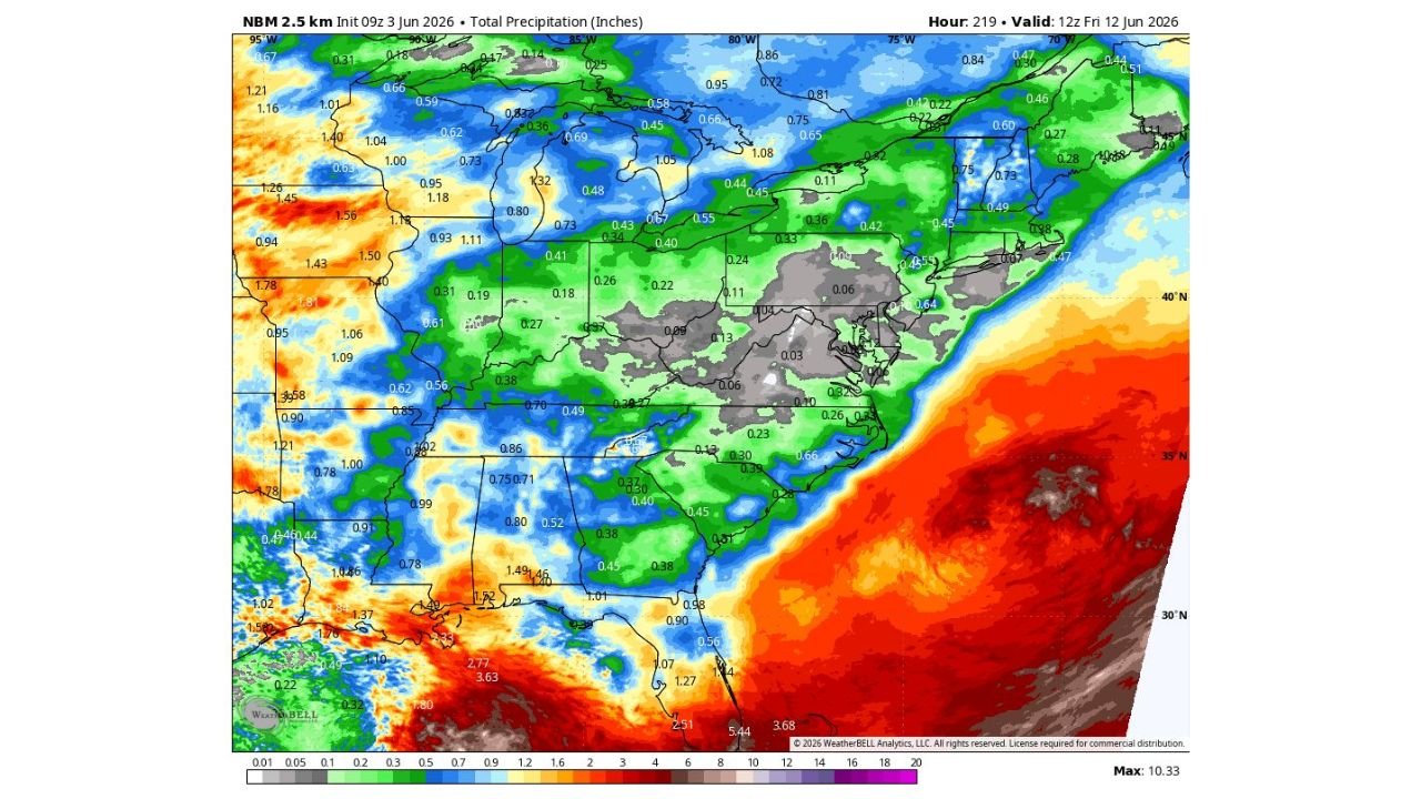
WASHINGTON, DC — The Washington DC area is currently experiencing a significant and worsening dry stretch as today marks the sixth consecutive rain-free day for the region, with NBM 2.5km precipitation data initialized June 3, 2026 at 09Z and valid through June 12, 2026 at 12Z clearly showing a pronounced rain hole centered directly over the DC corridor amid an otherwise active precipitation pattern across the broader eastern United States.
DC Area on Sixth Straight Rain-Free Day with Streak Likely to Reach Nine
Today marks the sixth consecutive dry day across the Washington DC metro area, and forecasters indicate the streak will likely grow to nine days before any shower activity returns on Sunday. The dry stretch is clearly visible on the NBM total precipitation forecast map, which shows extremely low precipitation values of 0.03 to 0.13 inches across the DC, Maryland, and northern Virginia corridor through June 12, 2026 while surrounding regions to the north and south receive significantly higher rainfall totals during the same period.
Sunday Showers Expected to Deliver Only 0.01 to 0.1 Inches of Rainfall
Even the anticipated Sunday shower opportunity is expected to deliver very little meaningful precipitation relief for the region. The front passing through is described as not particularly strong, with computer model blends projecting only 0.01 to 0.1 inches of rainfall for the DC area from Sunday’s system. Once Sunday’s front exits the region, high pressure is expected to build back in behind it, potentially shutting off rain chances once again and extending the overall dry pattern across the metro area.
Next Meaningful Rain Chances May Not Return Until June 14 to 18
Following Sunday’s minimal precipitation opportunity, the next window for meaningful rainfall across the Washington DC area may not arrive until sometime between June 14 and June 18, 2026. This extended dry outlook represents bad news for a region already dealing with drought conditions, as the continued absence of significant rainfall will further stress vegetation, deepen soil moisture deficits, and worsen existing drought conditions across the DC metro and surrounding areas of Maryland and Virginia.
NBM Precipitation Map Shows Stark Rain Hole Over DC Amid Wetter Surrounding Pattern
The NBM 2.5km total precipitation forecast through June 12, 2026 makes the DC rain hole visually striking, with gray and near-zero precipitation values blanketing the DC metro corridor while green and blue values indicating 0.5 to over 1.0 inches of rainfall cover areas to the north across the Great Lakes and to the south across the Gulf Coast and Southeast. The contrast between the DC area rain hole and the active precipitation surrounding it underscores the unusual and persistent nature of the dry pattern currently locked over the nation’s capital region.
Stay with GordonRamsayClub.com for the latest updates.

Leave a Reply