
SOUTHERN PLAINS, UNITED STATES — Tornado probabilities are increasing significantly heading into Friday afternoon and evening across a large corridor stretching from the Southern Plains to the Great Lakes, with meteorologists forecasting a possible High Impact Severe Weather Day and machine learning models highlighting Western Oklahoma as a primary area of concern for strong to intense tornado development.
Nado’Cast Probabilities Rising as High Impact Severe Weather Day Approaches
The Storm Prediction Center’s official forecast currently places the best tornado probabilities across Iowa, Wisconsin, and Illinois for Friday afternoon and evening. However, the Machine Learning Nado’Cast system is pointing strongly toward Western Oklahoma as an elevated area of concern, creating a notable split between the two forecasting tools as nighttime models continue to come in and refine the overall severe weather picture.
Tornado probability maps show a broad zone of elevated risk stretching across a large portion of the central United States, with the threat corridor running from the Southern Plains through the Midwest and into the Great Lakes region covering multiple states in the Friday afternoon and evening timeframe.
Tornado Probability Map Shows Multiple Zones of Elevated Risk Friday
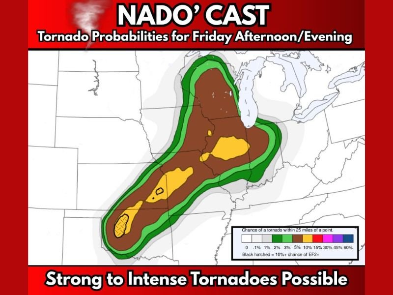
The Nado’Cast probability map shows a substantial area covered by elevated tornado chances, with colour-coded zones indicating varying levels of risk across the affected region. Brown zones cover a wide central corridor indicating meaningful tornado probabilities, while yellow zones represent areas where the chance of a tornado within 25 miles of a given point rises to between 15% and 30%.
Hatched areas visible on the Western Oklahoma zone indicate a 10% or greater chance of an EF2 or stronger tornado, meaning significant and potentially destructive tornadoes are possible in those specifically highlighted locations if conditions develop as currently forecast.
Western Oklahoma Flagged as Highest Concern Zone by Machine Learning Models
While the Storm Prediction Center leans toward Iowa, Wisconsin, and Illinois as the primary tornado corridors for Friday, the Machine Learning Nado’Cast is firmly pointing toward Western Oklahoma as its preferred area of highest concern. The divergence between traditional forecasting models and the machine learning system means residents across both zones need to remain on high alert throughout Friday afternoon and evening.
Western Oklahoma in particular should treat Friday as a potential significant severe weather event, with the combination of hatched EF2+ probability zones and machine learning model agreement making the area one of the most closely watched regions heading into the Friday weather window.
Residents Across Affected States Urged to Monitor Conditions Closely Friday
With strong to intense tornadoes described as possible across the broader threat zone, residents from the Southern Plains through the Great Lakes corridor are urged to have multiple ways to receive severe weather alerts, know their local shelter plans, and monitor conditions continuously throughout Friday afternoon and into the evening hours.
The situation remains developing as nighttime models continue arriving and forecasters refine the threat areas ahead of what could be a significant severe weather event across multiple states.
Stay with GordonRamsayClub.com for the latest weather updates and detailed forecast coverage.

Leave a Reply