
SOUTHEAST UNITED STATES / FLORIDA — A lingering frontal line is setting up a multi-day heavy rainfall event across the Southeast United States from Friday through Sunday, May 1 through 3, 2026 — with NOAA’s Weather Prediction Center issuing Excessive Rainfall Outlooks for three consecutive days showing flood risks expanding progressively southward and eventually encompassing the full Florida peninsula by the weekend.
Friday May 1 — Slight Risk of Excessive Rainfall Across Southeast
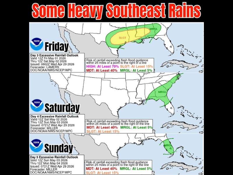
NOAA’s Day 3 Excessive Rainfall Outlook valid from Friday May 1 through Saturday May 2 shows the primary rainfall threat positioned across a broad Slight risk zone — carrying at least a 15% probability of rainfall exceeding flash flood guidance within 25 miles of any point — covering a corridor across the central Southeast region stretching toward the Mid-Atlantic coastline.
A wider Marginal risk zone — at least 5% probability — surrounds the Slight risk area and extends the flood-possible footprint across a larger portion of the Southeast. Forecaster Lamers issued this outlook on Wednesday April 29, reflecting confidence that a meaningful and potentially flooding rainfall event is developing for the Friday timeframe across the region.
Saturday May 2 — Flood Risk Shifts South Toward Florida and the Peninsula
By Saturday May 2, the Day 4 Excessive Rainfall Outlook issued by forecaster Miller shows a dramatic southward shift in the flood risk zone — with the Marginal risk area now repositioning southward and beginning to encompass the Florida peninsula and surrounding Gulf and Atlantic coastal areas.
This southward progression reflects the lingering frontal line pushing into Florida as the weekend develops — bringing the heavy rain threat directly to a state that has been notably dry and is now seeing genuine flood potential return to the forecast. Forecasters and weather watchers are noting with cautious optimism that significant rainfall may actually be materializing for Florida — a development that has been elusive in recent weeks.
Sunday May 3 — Marginal Flood Risk Focuses on Florida Peninsula
The Day 5 Excessive Rainfall Outlook for Sunday May 3 through Monday May 4 continues the southward trend — with the Marginal excessive rainfall risk zone tightening and focusing specifically on the Florida peninsula as the primary area of concern for the final day of the three-day rainfall event.
The Sunday outlook reflects the trailing end of the frontal system’s moisture delivery to the Southeast, with Florida absorbing the last significant round of rainfall from the lingering boundary before conditions begin to improve.
Florida Finally Seeing Real Rain Chances Return
Forecasters noted with genuine enthusiasm that flood chances are now showing for more of the Southeast — including Florida and the peninsula — representing what could be one of the better chances for meaningful and widespread rainfall across the Sunshine State in quite some time. The three-day progressive southward track of the excessive rainfall outlooks from Friday through Sunday paints a picture of a slow-moving frontal boundary delivering prolonged and potentially heavy rainfall accumulations across the region.
Residents across the Southeast and Florida should monitor local forecasts closely through the Friday to Sunday window for flash flood watches and warnings as the system develops. Stay with GordonRamsayClub.com for the latest updates.

Leave a Reply