
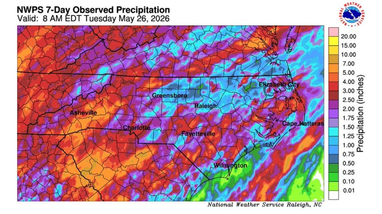
RALEIGH, NORTH CAROLINA — Radar-estimated precipitation data across North Carolina is revealing a significant multi-day rainfall event that has been unfolding since Thursday, with the National Weather Service Raleigh office releasing a 7-Day Observed Precipitation map valid at 8 AM EDT Tuesday May 26, 2026 showing widespread totals and a maximum observed value of 5.94 inches recorded in Clinton.
Clinton Records Maximum Observed Total of 5.94 Inches Since Rain Began Thursday
The highest observed rainfall total across the entire state since the rain event began on Thursday belongs to Clinton, where radar estimates show a maximum of 5.94 inches accumulated over the multi-day period. This stands well above the broader regional totals and represents a locally significant rainfall accumulation that has kept portions of the southern half of the state firmly in the heavier precipitation footprint throughout the event.
The deep red, purple, and pink shading visible across the southern tier of the state on the NWPS observed precipitation map reflects the elevated totals concentrated across that region since Thursday.
Southern North Carolina Seeing 1 to 4 Inch Totals Across the Broader Region
Across southern North Carolina more broadly, radar-estimated totals have generally fallen in the 1 to 4 inch range since rain began Thursday. Areas around Fayetteville, Wilmington, and Charlotte are sitting within this zone of elevated accumulations, with the warmer orange and red colors on the observed precipitation map confirming the higher end of the rainfall distribution across the southern portion of the state.
Wilmington and the Cape Fear region are also reflecting solid multi-day totals consistent with the 1 to 4 inch range that has characterized the southern half of the state throughout this prolonged rainfall event.
Northern North Carolina Totals Running Lower at 0.5 to 2 Inches Since Thursday
Across northern North Carolina including the Greensboro, Raleigh, Elizabeth City, and Asheville corridors, radar-estimated totals have been running more modest at 0.5 to 2 inches since Thursday. The cooler blue and green shading across the northern tier of the state on the NWS map reflects this lower end of the precipitation distribution compared to the heavier totals further south.
Residents across the southern half of the state should continue monitoring conditions as the ground remains saturated from several days of consistent rainfall since Thursday.
Stay with GordonRamsayClub.com for the latest updates.

Leave a Reply