
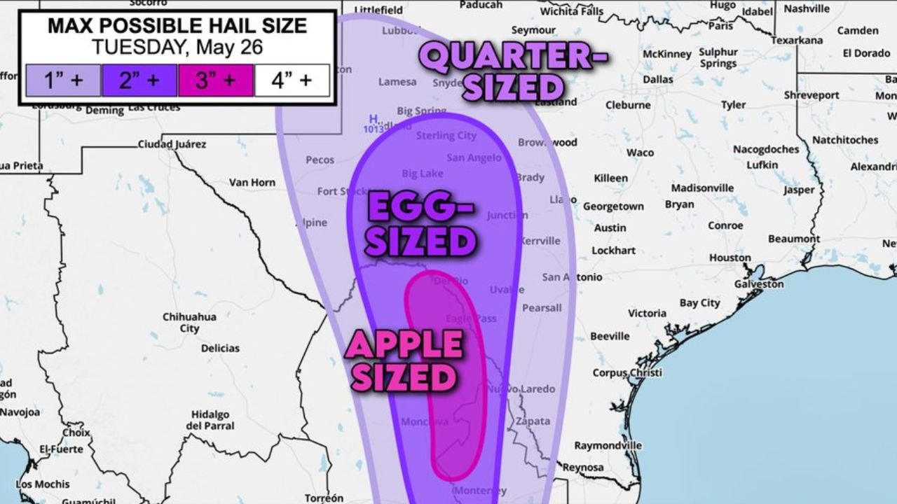
DEL RIO, TEXAS — An extremely dangerous hail threat is developing across Southwest Texas today Tuesday May 26, 2026, with forecasters warning that storms near Del Rio and Eagle Pass could produce damaging hail up to baseball size if they maintain supercell structure as they cross into the United States from Mexico, making storm mode a critical factor in determining just how severe today’s hail threat becomes.
Apple Sized Hail Up to 3 Inches Plus Possible Near Del Rio and Eagle Pass Corridor
The Max Possible Hail Size outlook for Tuesday May 26 shows the most extreme hail potential concentrated in a deep pink zone centered directly over the Del Rio and Eagle Pass corridor. This zone carries a maximum possible hail size of 3 inches plus, which falls into the apple-sized category and represents a life-threatening and catastrophically damaging hail threat for any area that receives a direct supercell strike.
Forecasters are clear that this extreme hail potential is contingent on storms remaining as organized supercells as they cross northward into the United States from Mexico. Storm mode will be the deciding factor between a catastrophic hail event and a more typical severe storm outcome across this zone today.
Egg Sized Hail Up to 2 Inches Plus Covers Broader West and Southwest Texas Zone
Surrounding the apple-sized core, a broader dark purple zone covers a wide swath of West and Southwest Texas including Fort Stockton, San Angelo, Big Lake, Junction, Uvalde, and Pearsall, where egg-sized hail of 2 inches plus is listed as the maximum possible size. This level of hail is still capable of causing serious damage to vehicles, roofs, crops, and any exposed property across the impacted area.
Quarter Sized Hail Threat Extends Northeast Toward Lubbock and San Angelo
The outermost light purple zone on the hail size outlook extends significantly further northeast, reaching toward Lubbock, Lamesa, Sterling City, and the broader Permian Basin region where quarter-sized hail of 1 inch plus represents the maximum possible size. While smaller than the threats further south, quarter-sized hail is still capable of causing vehicle damage and significant agricultural losses across the region.
Residents across Del Rio, Eagle Pass, and the broader Southwest Texas corridor should take shelter immediately if warnings are issued today and move vehicles indoors before storms arrive.
Stay with GordonRamsayClub.com for the latest updates.

Leave a Reply