
KANSAS / TEXAS — Meteorologists tracking today’s severe weather setup are sounding the alarm on an unusually low-confidence outlook for April 26, with the Storm Prediction Center’s primary tornado zone targeting Kansas but critical atmospheric data suggesting the threat could either fizzle entirely or shift well to the south into Texas.
SPC Points to Kansas But Data Tells a Different Story
The Storm Prediction Center has designated Kansas as the main tornado zone for today, but forecasters are expressing serious doubt about whether the environment will actually support significant storm development in that region.
High-resolution modeling data is showing little to no storm activity developing over Kansas, largely due to the influence of overnight storms that displaced and shunted moisture southward. Mistimed atmospheric waves are compounding the problem, leaving forecasters with a setup that currently does not support strong tornado development in the SPC’s primary target area.
CAPE Struggles Are the Core Problem
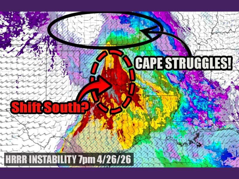
The critical issue driving today’s uncertainty is a significant lack of CAPE — Convective Available Potential Energy — the atmospheric instability that fuels severe thunderstorm and tornado development.
According to HRRR instability data valid for 7 p.m. on April 26, CAPE values over Kansas are failing to rebuild following last night’s storm activity. Without sufficient instability returning to the region, even well-timed wind shear and lift cannot produce the kind of organized supercell thunderstorms capable of generating strong tornadoes.
Primary Zone May Shift South Toward Texas
With Kansas struggling atmospherically, forecasters are watching whether the primary severe weather zone could shift well to the south, where instability values are comparatively greater. However, that scenario carries its own significant problem — there are no strong kicker waves in place to initiate and spark storm development across the southern zone.
The one wildcard remaining is a possible outflow boundary across Texas, which could potentially provide enough of a trigger to fire storms — but only if that boundary does not wash out before the evening hours.
Forecast Confidence Extremely Low — Updates Expected
Forecasters are openly acknowledging that today’s setup is one of the most difficult to pin down, with too many competing factors and not enough model agreement to issue a confident outlook at this stage. Further adjustments to the severe weather outlook are expected as the day progresses and additional data comes in.
Residents across Kansas and northern Texas should continue monitoring local National Weather Service updates closely throughout the afternoon and evening of April 26. Stay with GordonRamsayClub.com for the latest updates.
Leave a Reply