
NORTH TEXAS / DALLAS-FORT WORTH — While Monday brings record-breaking heat to North Texas with temperatures expected to reach 92 to 94 degrees, Tuesday tells a completely different story — a cold front and approaching disturbance will spark scattered severe storms east of I-35 from 4 p.m. through 10 p.m., bringing a multi-threat severe weather package to a wide corridor of North and East Texas communities.
Record Heat Monday Before Tuesday Storm Threat Arrives
North Texas is experiencing no rain or storm activity Monday, instead baking under intense sunshine with temperatures forecast to reach the 92 to 94 degree range — potentially breaking the existing heat record of 92 degrees for the date. Residents should expect a hot and sunny Monday before conditions change dramatically heading into Tuesday afternoon.
Tuesday Storm Window 4pm to 10pm East of I-35
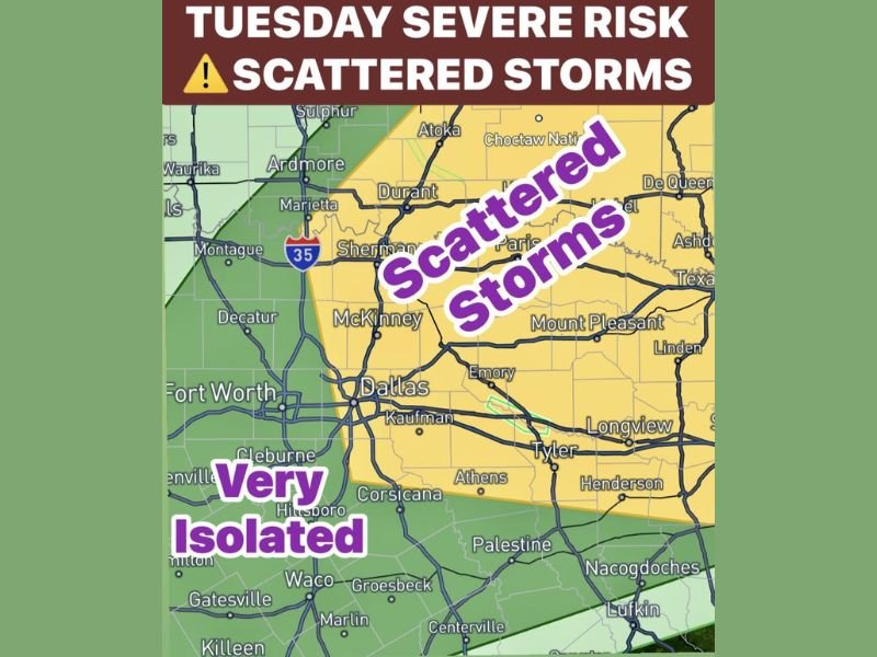
The severe weather risk for Tuesday is tied directly to an approaching cold front and atmospheric disturbance expected to push into the region after 4 p.m. Scattered storms will begin forming ahead of the front, primarily targeting communities east of Interstate 35 — leaving areas to the west of I-35 in a very isolated and significantly lower risk zone.
The active storm window runs from 4 p.m. through 10 p.m. Tuesday, with overall storm coverage estimated at 40% — meaning roughly 60% of the area may see little to nothing from this system depending on exact storm placement and movement.
Hail Up to 2 Inches 65mph Winds and Isolated Tornado Possible
The threat parameters for Tuesday’s stronger storms are significant for those who do end up under active cells. Forecasters have outlined the following specific hazards for the 4 p.m. to 10 p.m. window — hail ranging from pea size up to 2 inches in the strongest storms, damaging winds between 55 and 65 mph, an isolated spin-up tornado possibility, and frequent lightning throughout the storm activity period.
While these threats are real, the localized and scattered nature of the storm coverage means impact will be highly dependent on exactly where individual cells develop and track across the East Texas corridor.
Communities in the Primary Impact Zone
The yellow scattered storm zone on Tuesday’s outlook map covers a broad swath of North and East Texas communities east of I-35 — including Sherman, McKinney, Dallas, Kaufman, Emory, Mount Pleasant, Paris, Longview, Tyler, Henderson, Athens, Palestine, Corsicana, and Nacogdoches among others stretching toward the Texas-Arkansas border region.
Fort Worth and communities west of I-35 including Decatur, Cleburne, Hillsboro, Waco, and Gatesville sit in the very isolated zone with significantly reduced but not completely eliminated storm risk.
What Tuesday Storm Risk Means for Residents
With 40% storm coverage forecast, Tuesday’s severe weather is not a widespread outbreak event — but for any community that does see a storm develop overhead, the threats of 2-inch hail and 65 mph winds are serious enough to cause significant property and vehicle damage. Residents across the entire East Texas corridor east of I-35 should monitor forecasts closely throughout Tuesday and have a weather alert method active during the 4 p.m. to 10 p.m. primary window. Stay with GordonRamsayClub.com for the latest updates.
Leave a Reply