
KANSAS / CENTRAL PLAINS — The Storm Prediction Center has issued its latest Day 1 Categorical Outlook, pulling the Enhanced risk zone southward out of Nebraska and repositioning it firmly over Kansas, with a Moderate risk area now visible at the core of the threat zone — signaling a significant and evolving severe weather setup across the Central Plains today, April 26.
Latest SPC Outlook Shifts Enhanced Risk Into Kansas
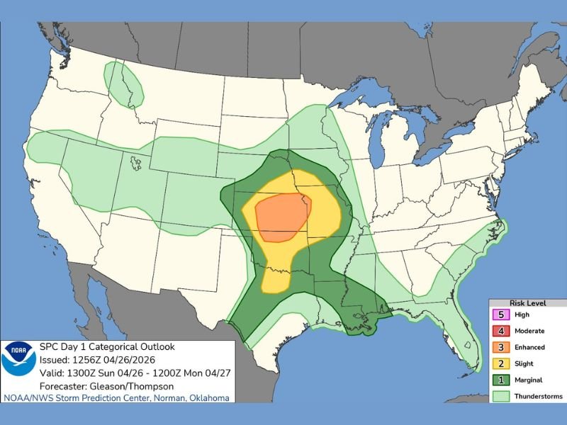
Issued at 1256Z on April 26, 2026 and valid from 1300Z Sunday through 1200Z Monday, the updated SPC outlook reflects a meaningful southward adjustment from earlier forecasts. The Enhanced risk — Level 3 on the SPC’s five-tier scale — has been pulled out of Nebraska and is now centered over Kansas, covering a broad swath of the state.
Forecasters Gleason and Thompson out of the NOAA/NWS Storm Prediction Center in Norman, Oklahoma are the forecasters of record on this outlook.
Moderate Risk Sits at the Bull’s-Eye
At the core of today’s threat sits a Level 4 Moderate risk zone — one step below the highest possible High risk category — concentrated over central Kansas. This is a significant upgrade that indicates forecasters have increased confidence in organized, potentially long-track severe storms capable of producing large hail, damaging winds, and tornadoes across the most heavily shaded areas.
A Moderate risk designation is issued on fewer than 10% of days in any given year, making today’s setup a notably serious severe weather event for affected communities.
Slight and Marginal Risks Spread Across Multiple States
Surrounding the Enhanced and Moderate cores, a broad Slight risk — Level 2 — fans out across a large multi-state area covering portions of Kansas, Missouri, Oklahoma, Arkansas, and into parts of the Gulf South region. A wider Marginal and general thunderstorm risk extends even further, reaching from the northern Plains down through the Gulf Coast and touching the Eastern Seaboard.
This wide footprint indicates that while the most dangerous storms are expected over Kansas, scattered severe weather impacts are possible across a much larger area throughout the day and evening.
What Residents Should Do Now
Anyone located within the Enhanced or Moderate risk zones in Kansas should treat today’s outlook with utmost seriousness. Residents should have multiple ways to receive weather warnings — including a NOAA weather radio, a reliable weather app with push alerts, and access to local television coverage.
Have a shelter plan ready before storms arrive. Do not wait for a tornado warning to begin preparing. Conditions can deteriorate rapidly once storms initiate. Stay with GordonRamsayClub.com for the latest updates.

Leave a Reply