
GULF OF MEXICO — This hurricane season is shaping up to be an El Nino influenced year, with increased wind shear across the Caribbean expected to suppress storm development in the traditional tropical breeding grounds while forecasters are pointing to the Gulf of Mexico and the western Atlantic as the historic areas most likely to produce named storm activity this season.
El Nino years typically result in fewer named storms overall due to the increased wind shear that shuts down Caribbean development, but specific zones outside the shear corridor remain capable of producing dangerous storms when conditions align.
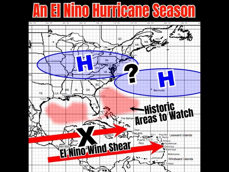
El Nino Wind Shear Shutting Down Caribbean as Primary Storm Development Zone
The dominant feature of this El Nino hurricane season is the strong wind shear sweeping across the Caribbean basin from Central America through Jamaica, Puerto Rico, and the Leeward and Windward Islands, effectively suppressing tropical storm and hurricane development across one of the most historically active regions of the Atlantic basin.
El Nino years are well established as seasons with reduced overall named storm counts, primarily because the increased wind shear across the Caribbean tears apart developing tropical systems before they can organize into named storms or hurricanes.
The combination of high pressure systems anchored over the eastern United States and Bermuda are shown driving storm tracks further west in this El Nino pattern, which historically has pushed any storms that do develop toward the Gulf Coast and eastern seaboard rather than the open Atlantic.
Gulf of Mexico Identified as Top Area to Watch Due to Warm Waters and Light Shear
Despite the overall suppressed activity expected from El Nino, the Gulf of Mexico stands out as a significant area of concern this season due to waters running warmer than average combined with lighter wind shear compared to the Caribbean basin.
The combination of above average Gulf water temperatures and reduced shear creates a more favorable environment for homegrown Gulf storm development, which forecasters describe as always a spot to watch regardless of the overall seasonal pattern in place.
Historically in El Nino years, the Gulf has produced impactful storms even when the broader Atlantic basin remains quiet, making the Gulf Coast states from Texas through Florida particularly relevant areas to monitor throughout the 2026 hurricane season.
Western Atlantic and High Pressure Pattern Also Creating Storm Track Concerns
Beyond the Gulf, the western Atlantic near Bermuda and the Bahamas represents a second historic area to watch during El Nino hurricane seasons, where high pressure systems have historically combined to drive storms on a more westward track toward the United States coastline.
The question mark shown over the western Atlantic in the forecast graphic reflects the uncertainty around whether high pressure will set up in a configuration that pushes any developing systems toward the East Coast or keeps them out to sea during the 2026 season.
Forecasters are urging residents across Gulf Coast and eastern seaboard states to remain weather aware throughout the season as the El Nino pattern, while suppressing overall storm counts, does not eliminate the risk of impactful storms in the key historic watch zones identified for this year. Stay with GordonRamsayClub.com for the latest updates.

Leave a Reply