
WHITEWRIGHT / TOM BEAN / LEONARD, TEXAS — A violent early morning hailstorm slammed across a wide corridor of North Texas on Sunday, with radar estimating grapefruit-size hail up to 4.5 inches over Whitewright, Tom Bean, and Leonard — while a confirmed ground report of 3.5-inch hail in Whitewright was recorded at just 6:18 a.m.
Radar Estimates Grapefruit-Size Hail at 4.5 Inches
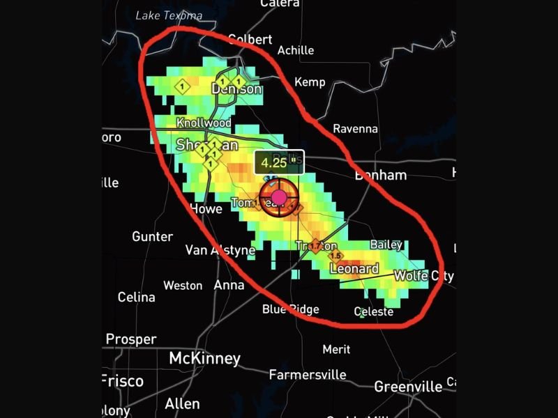
Doppler radar data placed the peak hail size estimate at 4.5 inches near the Tom Bean area, with radar-indicated values of 4.25 inches also visible on hail swath mapping directly over the same corridor. These are extraordinary hail sizes — grapefruit-scale hailstones cause catastrophic damage to vehicles, rooftops, windows, and any exposed property or livestock in their path.
The radar-indicated bull’s-eye of the most intense hail was centered squarely over Tom Bean, with the intense core signature clearly visible on hail swath imagery.
3.5-Inch Hail Confirmed on the Ground in Whitewright
Beyond radar estimates, a ground-truth confirmation came in from Whitewright at 6:18 a.m., with hail measured at 3.5 inches — well above the 1-inch threshold for severe hail and large enough to cause serious structural and vehicle damage across the affected area.
Ground-confirmed reports of this magnitude at such an early morning hour indicate the storm system moved aggressively through the region before most residents were even awake.
Hail Swath Runs From Denison to Wolfe City
Radar hail swath mapping shows the destructive corridor stretching from Denison in the north all the way down through Sherman, Knollwood, Tom Bean, Trenton, Leonard, and extending to Wolfe City in the southeast — a significant multi-community impact zone covering a large portion of Grayson and Fannin counties.
Communities along this swath including Howe, Van Alstyne, Bailey, and Celeste also fall within the broader impact area and likely experienced hail of varying sizes as the storm tracked southeast.
What This Level of Hail Damage Looks Like
Hailstones in the 3.5 to 4.5-inch range are capable of puncturing roofing materials, shattering skylights and windows, destroying vehicle hoods, windshields and body panels beyond repair, and stripping vegetation completely. Residents across the entire swath from Denison to Wolfe City should inspect their properties carefully for damage as daylight allows.
Insurance claims for hail events of this magnitude can be extensive. Residents are advised to document all damage thoroughly with photographs before any cleanup or repairs begin. Stay with GordonRamsayClub.com for the latest updates.

Leave a Reply