
CHICAGO / ILLINOIS — A powerful and dangerous severe weather system is bearing down on the entire state of Illinois for Monday, April 27, 2026, with forecasters warning that destructive storms hitting Chicagoland tomorrow evening carry an extremely high probability — driven by massive wind shear, strong frontal forcing, and a two-wave storm structure that makes the evening hours particularly dangerous.
Two Waves of Storms Moving In Monday Afternoon and Evening
Models are indicating two distinct rounds of severe weather striking Illinois on Monday. The first wave is expected mid-afternoon between 2 and 4 p.m., carrying a lower but real severe threat. The second and far more intense line of storms is projected to arrive in the evening — potentially around 8 p.m. — unleashing the full destructive force of the system.
Forecasters caution that if the afternoon wave fires first, it could consume some available atmospheric energy before the main event. However, the overall ceiling for severe weather remains extremely high regardless of how the first wave performs.
Widespread Damaging Winds Are the Biggest Threat
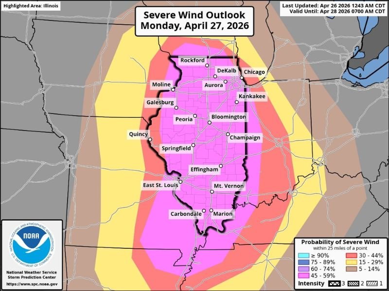
The primary and most dangerous threat from Monday’s system is not tornadoes or hail — it is widespread powerful damaging winds. Extremely strong frontal forcing combined with significant wind energy aloft creates conditions where upper-level winds transfer directly down to the surface, capable of producing destructive straight-line wind damage across essentially the entire state.
The Severe Wind Outlook for Monday shows the highest probability corridor running through central and northern Illinois — covering Rockford, DeKalb, Chicago, Aurora, Kankakee, Peoria, Bloomington, Champaign, Springfield, Effingham, and southward through Carbondale and Marion.
Tornadoes Possible Statewide — Higher Risk South of Chicago
Monday’s Tornado Outlook places a hatched tornado probability zone across a broad portion of Illinois. The highest tornado risk sits south of the Chicago metro, but Chicagoland and northern Illinois communities remain firmly inside the tornado-possible zone. Strong frontal dynamics and available wind shear make embedded tornadoes within the evening squall line a real and serious possibility.
Hail rounds out the threat picture as a lesser but non-zero danger from this system.
NOAA Places Nearly All of Illinois Under Moderate to Enhanced Risk
NOAA’s Severe Weather Outlook for Monday April 27 places virtually the entire state of Illinois under Enhanced to Moderate risk. The Moderate risk zone — Level 4 out of 5 — covers a large central corridor stretching from Rockford and DeKalb in the north through Peoria, Bloomington, Springfield, Effingham and down to Carbondale and Marion in the south.
Chicago sits at the northern edge of the Moderate zone — still a life-threatening severe weather designation that should be taken with full seriousness.
Illinois Residents Must Prepare Before Monday Afternoon
Forecasters are direct — the chances of dangerous storms not impacting Chicagoland tomorrow evening are very low. Residents across all of Illinois should act now while conditions remain calm.
Secure all outdoor items before Monday afternoon. Have multiple severe weather alert methods active. Know your shelter location in advance — lowest interior room of a sturdy building away from all windows. Do not wait for warnings before taking action when storms approach Monday evening. Stay with GordonRamsayClub.com for the latest updates.
Leave a Reply