
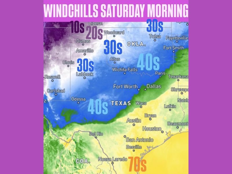
AMARILLO, TEXAS — Windchills had already fallen into the 20s across parts of the Texas and Oklahoma Panhandles tonight as a cold front continued racing southward through the region. By Saturday morning the windchill map showed a dramatic temperature drop stretching from the 10s in the Liberal Kansas area down through the 20s across the Panhandles, the 30s across central Oklahoma and the Texas South Plains, and the 40s covering the Fort Worth, Dallas, Odessa, and Lubbock zones, with only far southern Texas holding onto warmer conditions.
Windchills Already in the 20s Across Texas and Oklahoma Panhandles Tonight
The cold front wasted no time making its presence felt across the Panhandle region, with windchills already crashing into the 20s across areas including Dumas, Amarillo, and Woodward as the front pushed southward tonight. The most extreme windchill values were concentrated in the far northern zone near Liberal, Kansas, where temperatures were feeling like the 10s as the cold air mass settled into the region.
Forecasters noted the cold front was continuing to race southward, meaning the coldest windchill values were still working their way deeper into Texas and Oklahoma overnight.
Saturday Morning Windchill Breakdown Across Texas and Oklahoma
The Saturday morning windchill forecast painted a sharp and widespread cold picture across the entire region. The zone-by-zone breakdown based on the forecast graphic showed the following expected windchill ranges by morning — Liberal and the far northern Kansas border area in the 10s, the Texas and Oklahoma Panhandles including Dumas, Amarillo, Woodward, and Clovis in the 20s, central Oklahoma including Altus and the Lubbock area of Texas in the 30s, and a broad zone covering Wichita Falls, Fort Worth, Dallas, Odessa, and much of central Texas in the 40s.
Eastern portions of Oklahoma including Tulsa, Fort Smith, and Fayetteville were holding onto slightly milder windchills in the 30s to 40s range, while far southern Texas toward San Antonio, Houston, and the Gulf Coast remained in warmer territory.
Cold Front Continuing to Race South — Warmer Air Retreating to Southern Texas and Gulf Coast
The sharp boundary between the cold and warm air masses was clearly visible on the windchill map, with the transition zone running roughly from the Dallas and Paris corridor westward through Wichita Falls and into eastern New Mexico. South of that line, areas including Austin, Houston, San Antonio, and Beaumont were still holding onto significantly warmer conditions, with far southern Texas near Nuevo Laredo and the coast remaining in the 70s.
Residents across the entire Texas and Oklahoma region were advised to prepare for a noticeably sharp and cold Saturday morning with windchills making conditions feel significantly colder than the actual air temperature across the warned zones. Stay with GordonRamsayClub.com for the latest weather updates and detailed forecast coverage.

Leave a Reply