
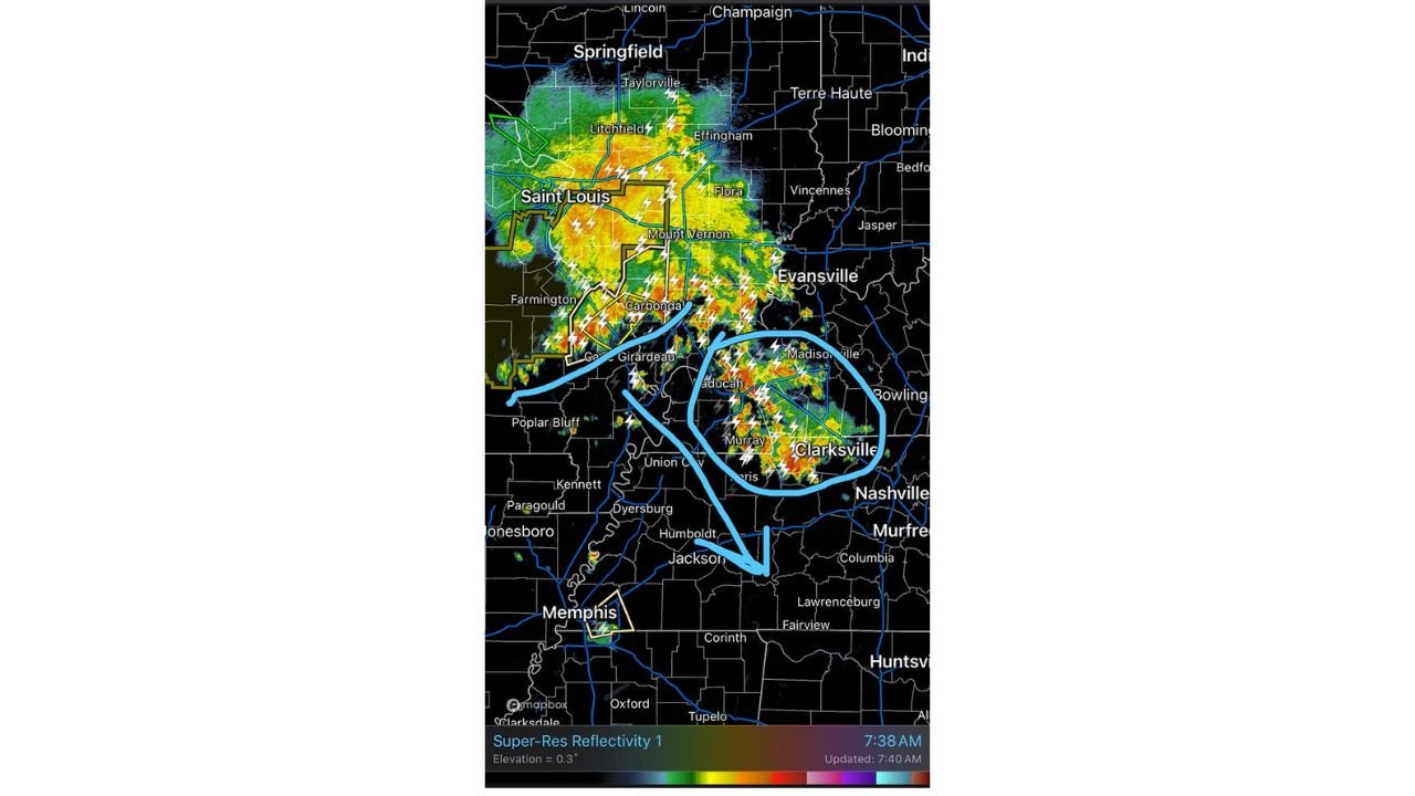
NASHVILLE, TENNESSEE — An organizing Mesoscale Convective System is currently tracking across western Tennessee, southern Illinois, and western Kentucky this morning, with radar at 7:40 AM showing intense lightning activity and heavy storm cores concentrated across the Paducah, Murray, Clarksville, and Cape Girardeau corridor as meteorologists watch the system closely for further development.
MCS Getting Organized with Greatest Severe Risk Currently West of I-65
Forecasters monitoring live radar are noting that the MCS is just now beginning to get its act together and organize into a more coherent and potentially dangerous system. The greatest severe weather risk at this time remains west of Interstate 65, keeping communities along and east of the I-65 corridor in a somewhat more favorable position for now. However, the situation remains fluid and conditions could change rapidly as the system continues to strengthen and consolidate through the morning hours.
Rain Blob Along I-65 Corridor May Help Buffer Significant Severe Weather Risk
A separate blob of rain currently tracking along the Interstate 65 corridor is being watched as a potential buffer that could help areas along I-65 avoid significant severe weather risk, provided it does not strengthen further on its own. The highly electrical nature of this storm activity is also notable, with frequent and intense lightning strikes observed across the entire active zone from Saint Louis and Carbondale southward through Cape Girardeau, Paducah, Murray, and toward Clarksville and Nashville.
Active Storm Cores Concentrated from Paducah and Murray Through Clarksville
Live radar shows the most intense storm cores currently clustered in a zone stretching from Paducah and Murray in western Kentucky southward through Clarksville and toward the Nashville metro. Additional storm activity is ongoing across southern Illinois near Carbondale, Mount Vernon, and Flora, with the broader system stretching from Springfield and Saint Louis in the north down through Memphis and into northern Mississippi.
Residents West of I-65 Should Remain Alert as System Continues to Organize
With the MCS actively organizing and the greatest severe risk sitting west of Interstate 65, residents across western Tennessee, western Kentucky, and southern Illinois should remain closely connected to local weather updates throughout the morning as conditions continue to evolve rapidly.
Stay with GordonRamsayClub.com for the latest updates.

Leave a Reply