
SOUTHERN ALABAMA, SOUTHWEST GEORGIA AND FLORIDA PANHANDLE — A TORCON 3 tornado threat is in place today into tonight across Southern Alabama, Southwest Georgia, and the Florida Panhandle as plenty of storms remain active through the day. Intense straight line winds capable of causing tree damage and intermittent power outages are the primary hazard alongside the tornado threat, while heavy rain is also producing isolated flash flooding concerns across the region. Drivers are warned to watch for high water on roadways and the risk of hydroplaning throughout the day.
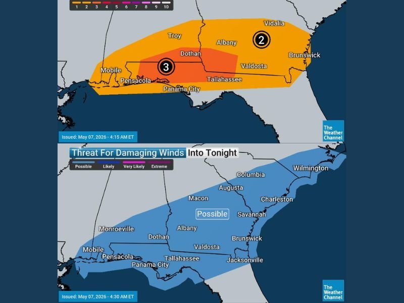
What TORCON 3 Means for the Region
A TORCON 3 rating indicates a meaningful and real tornado threat across the outlined zone covering Southern Alabama and the Florida Panhandle including Dothan, Pensacola, Panama City, and Tallahassee. While the hail threat has come down compared to earlier in the event, tornadoes remain possible with several storms still expected to move through the region throughout the day and into tonight.
A TORCON 2 zone sits to the north and east covering Troy, Albany, Dothan, Valdosta, and extending toward Brunswick and Vidalia in southern Georgia, keeping a wide swath of the Deep South under an active tornado threat through tonight.
Straight Line Winds Remain the Primary Danger
Intense straight line winds are being identified as the most widespread and damaging threat across the region today into tonight. Tree damage is expected with the strongest wind gusts, and intermittent power outages are considered likely across portions of Southern Alabama, Southwest Georgia, and the Florida Panhandle as storm cells push through the area throughout the day.
The damaging wind threat map shows a possible level of concern extending from Mobile and Pensacola northeast through Dothan, Albany, Valdosta, and toward Savannah and Brunswick along the Georgia coast.
Flash Flooding and Road Hazards
Heavy rainfall accompanying today’s storms is generating isolated flash flooding concerns across the affected region. Standing water on roadways and the risk of hydroplaning are real dangers for drivers across Southern Alabama, the Florida Panhandle, and Southwest Georgia throughout Thursday.
Residents are strongly urged to avoid driving through flooded roadways and to slow down on wet roads where hydroplaning conditions may exist even without visible standing water.
What Residents Must Do
All residents across Pensacola, Panama City, Dothan, Mobile, Tallahassee, Valdosta, and surrounding communities are urged to remain weather aware throughout the entire day and evening. Have shelter plans ready, keep weather alerts active, and avoid unnecessary travel during the heaviest storm activity today into tonight. Stay with GordonRamsayClub.com for the latest updates.
Leave a Reply