
GREENVILLE, SOUTH CAROLINA — Heavy rain has been pounding Greenville and the surrounding Upstate South Carolina region since midnight, with at least 2 inches of rainfall already recorded in Greenville alone by early Thursday morning. Additional heavy rain is continuing to track through the area during the early morning hours, with a brief break expected before one more batch pushes through mid-morning before the system finally exits the region.
How Much Rain Has Already Fallen
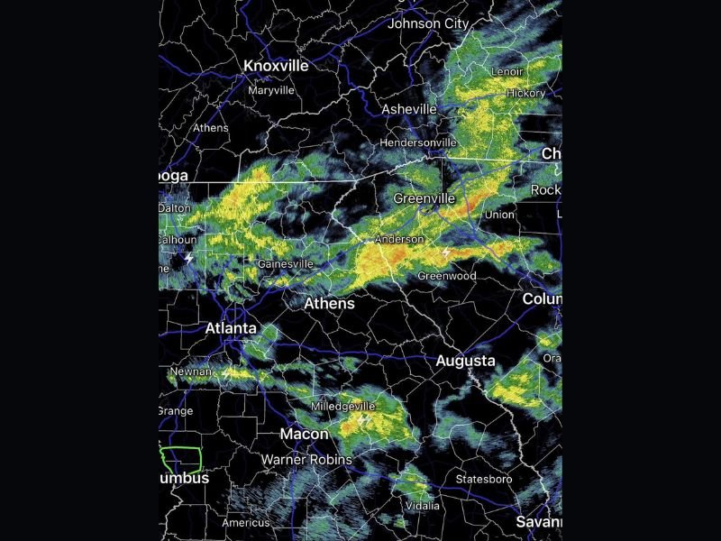
A weather observer in Greenville confirmed recording 2 full inches of rainfall since midnight alone, highlighting just how significant the overnight and early morning rainfall totals have been across Upstate South Carolina. The radar image shows intense bands of heavy rainfall concentrated across the Greenville, Anderson, and Greenwood corridor, with additional cells tracking through the broader region stretching from Atlanta and Athens in Georgia through Asheville and Hendersonville in western North Carolina.
Lightning strikes are visible on radar across multiple areas including the Anderson and Gainesville zones, indicating active thunderstorm cells embedded within the broader rain event moving through the region.
What to Expect Through Mid-Morning
The heavy rain is expected to take a brief pause before one additional batch pushes through the area around mid-morning. Once that final round exits the region, conditions are expected to begin improving across Greenville and surrounding Upstate South Carolina communities.
Residents across the region should be prepared for continued heavy rainfall and reduced visibility on roadways through the mid-morning hours before the system fully clears out. Flash flooding remains a concern given the significant rainfall totals already accumulated since midnight across the Greenville area and surrounding communities.
Areas Currently Impacted
The radar shows active and heavy rainfall bands pushing through a wide corridor covering multiple states. Georgia communities including Atlanta, Gainesville, Calhoun, Dalton, Athens, Macon, and Warner Robins are all seeing rain activity, while western North Carolina including Asheville, Hendersonville, Hickory, and Lenoir are also experiencing heavy rainfall from the same system.
Knoxville, Maryville, and Johnson City in Tennessee sit on the northern edge of the rain activity as the system continues its track through the broader Southeast region Thursday morning.
Road Safety Warning
With 2 inches of rain already recorded in Greenville since midnight and more on the way through mid-morning, drivers across Upstate South Carolina and surrounding areas are urged to use extreme caution on roadways. Standing water, reduced visibility, and hydroplaning conditions are all possible during the remaining heavy rain bands pushing through the region before the system exits later Thursday morning. Stay with GordonRamsayClub.com for the latest updates.
Leave a Reply