
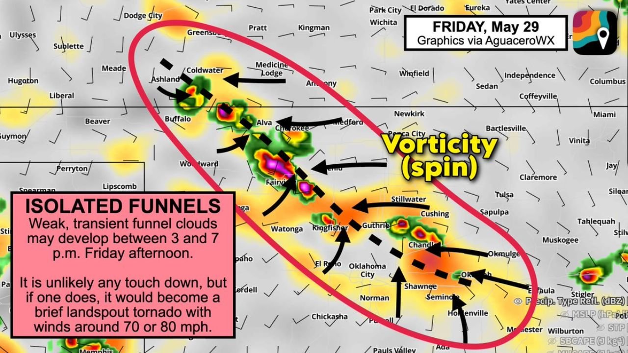
WOODWARD, OKLAHOMA — A sneaky and somewhat unusual weather setup is generating attention across northwest Oklahoma and south-central Kansas for Friday May 29, 2026, with MyRadar Weather and AguaceroWX graphics flagging a low but not zero risk of cold-air funnel clouds and a brief landspout tornado developing across the region between 3 and 7 PM Friday afternoon as vorticity and spin concentrate along a focused corridor from southwestern Kansas through central Oklahoma.
Isolated Funnel Clouds Possible Between 3 and 7 PM Across the Northwest Oklahoma Corridor
The AguaceroWX Friday May 29 graphic shows a red oval zone of concern encompassing a corridor stretching from the Ashland, Coldwater, and Medicine Lodge area in southwestern Kansas southward through Buffalo, Alva, Cherokee, Woodward, Fairview, Watonga, Kingfisher, Guthrie, and extending toward Oklahoma City and Chandler in central Oklahoma. This outlined zone represents the area where isolated weak and transient funnel clouds may develop during the 3 to 7 PM window Friday afternoon.
The vorticity and spin annotations on the map highlight concentrated areas of atmospheric rotation within the outlined zone, providing the low-level spin necessary for cold-air funnel development under the right atmospheric conditions during the afternoon hours.
Brief Landspout Tornado With EF0 Winds Around 70 to 80 MPH Cannot Be Ruled Out
While forecasters emphasize that it is unlikely any funnel cloud would touch down and produce a surface tornado, the risk is acknowledged as low but not zero. If a landspout tornado does develop from one of the funnel clouds, it would likely be brief and weak, carrying EF0 intensity winds on the order of 70 to 80 mph. MyRadar Weather specifically notes that any landspout would be a short-lived and transient event rather than a long-track or intense tornado.
The cold-air funnel mechanism driving this potential is distinct from the supercell tornado process, forming instead under cold upper-level air combined with surface heating and low-level vorticity rather than through organized thunderstorm rotation. This makes the threat conditional and highly localized rather than widespread across the region.
Vorticity Concentration Visible Across the Outlined Zone From Kansas Into Central Oklahoma
The AguaceroWX graphic clearly annotates vorticity spin concentrations across multiple points within the outlined red oval, with arrows indicating the convergence of spin across the Alva, Cherokee, Woodward, Kingfisher, and Guthrie corridors. Residents across northwest Oklahoma and adjacent southwestern Kansas should remain weather-aware Friday afternoon and monitor any funnel cloud sightings between 3 and 7 PM.
Stay with GordonRamsayClub.com for the latest updates.

Leave a Reply