
HOUSTON, TEXAS — The National Hurricane Center is monitoring a broad area of low pressure currently producing disorganized shower and thunderstorm activity over eastern Mexico, with a 20 percent chance of development over the next seven days as the system could re-emerge over the northwestern Gulf around midweek and enhance rainfall totals across Texas, Louisiana, and the Deep South.
Area of Interest Holds Low Development Chances Through the Week
The NHC tropical outlook valid 1200 UTC June 14 places Area of Interest 1 over the northwestern Gulf near the Texas coastline, carrying a 0 percent chance of development over the next two days and a 20 percent chance over seven days. The system is expected to remain inland over northeastern Mexico or southern Texas for the next day or so before any potential re-emergence over Gulf waters.
Sea surface temperatures across the Gulf of Mexico are running in the 28 to 30 degree Celsius range, providing ample warm water for development if the system can organize after re-emerging.
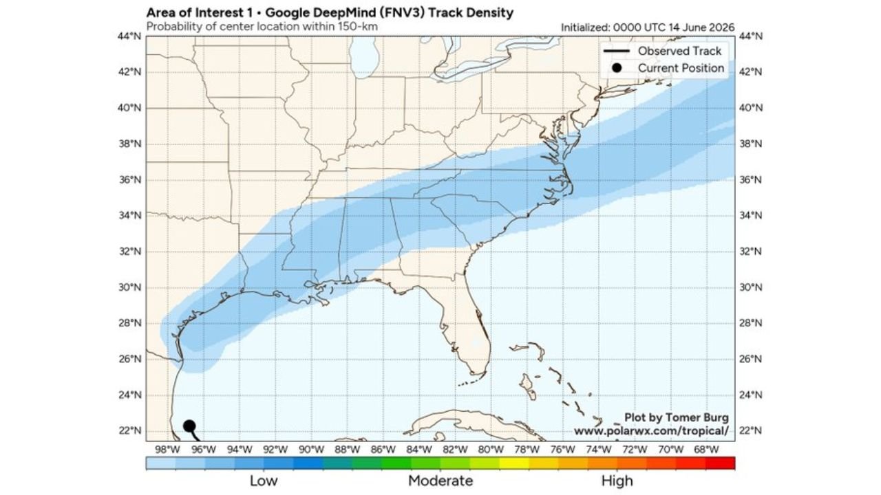
Track Density Model Shows Low Probability Path Toward the Southeast
The Google DeepMind FNV3 track density model initialized at 0000 UTC June 14 shows a low probability corridor extending from the current position near the Texas and Mexico border eastward along the Gulf Coast and into the Southeast, covering Louisiana, Mississippi, Alabama, Florida, Georgia, and the Carolinas. The shading reflects low confidence given the system’s current disorganized state and marginal development conditions expected at re-emergence.
A frontal boundary interaction around midweek is the key factor forecasters are watching, though conditions are only expected to be marginally conducive for organization.
Deep South Rainfall Totals Could Reach 4 to 7 Inches This Week
The seven-day precipitation forecast ending Sunday June 21 at 8AM EDT shows substantial rainfall totals building across Texas, Louisiana, Mississippi, and Alabama regardless of tropical development. Totals of 4 to 7 inches are forecast across a broad corridor covering Dallas, Shreveport, and into central Mississippi and Alabama, with the deeper tropical moisture from this system contributing to the enhanced totals late this week.
Residents across Texas, Louisiana, and the Deep South should monitor flooding potential as this moisture-rich pattern unfolds through the week regardless of whether organized tropical development occurs.
Stay with GordonRamsayClub.com for the latest updates.

Leave a Reply