
KANSAS CITY, MISSOURI — The SPC has upgraded Wednesday’s severe weather setup to a 30 percent severe risk across Missouri, Illinois, and eastern Kansas, with forecasters noting that a 30 percent probability this far out is rare and has captured significant attention as the biggest threat shifts west into the Lower Missouri Valley.
30 Percent Risk Core Centers on Kansas City Through St. Louis
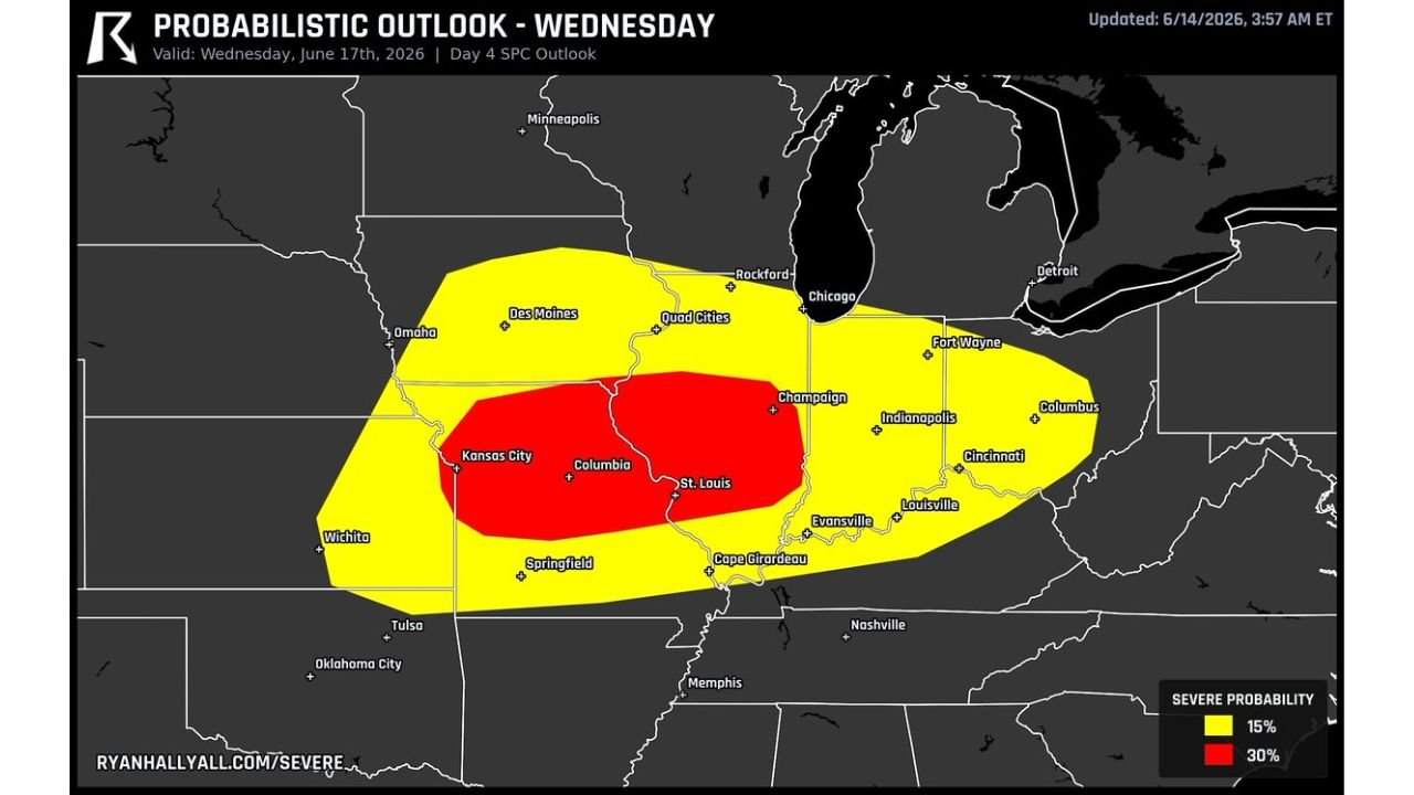
The Day 4 SPC probabilistic outlook updated June 14 at 3:57 AM ET valid Wednesday June 17 shows a 30 percent severe probability zone in red centered directly over Kansas City, Columbia, St. Louis, Champaign, and Cape Girardeau. This represents an upgrade from the previously flagged setup and reflects high forecaster confidence at this range, which is uncommon for a Day 4 outlook.
A 15 percent zone in yellow surrounds the core, extending coverage from Omaha and Des Moines through Quad Cities, Chicago, Indianapolis, Cincinnati, and Louisville.
Biggest Threat Shifts West Into the Lower Missouri Valley
Forecasters are highlighting the Lower Missouri Valley as the area where the biggest threat now resides. Strong storms could spin up first across this corridor before clumping into one large line that produces a long swath of damaging wind extending into the evening hours.
The westward shift of the highest threat area means Kansas City and the surrounding Lower Missouri Valley communities now sit at the center of Wednesday’s developing severe weather concern.
Trend Remains Upward With Room for Further Adjustment
While there is still room for the risk area to nudge around as Wednesday approaches, forecasters note the overall trend has been upward in terms of both probability and confidence. The rare nature of a 30 percent Day 4 outlook signals this setup deserves close attention from residents across Missouri, Illinois, and eastern Kansas in the coming days.
Residents across Kansas City, Columbia, St. Louis, and the broader highlighted corridor should continue monitoring forecast updates as Wednesday approaches.
Stay with GordonRamsayClub.com for the latest updates.

Leave a Reply