
HARRISBURG, PENNSYLVANIA — The Storm Prediction Center is continuing to track a severe weather threat for Thursday June 18, maintaining a 15 percent severe risk while shifting the focus area eastward to now center directly over Pennsylvania, West Virginia, and Virginia as a line of storms pushes through the mountains and into the Mid-Atlantic.
SPC Maintains 15 Percent Risk Now Centered on the Mid-Atlantic
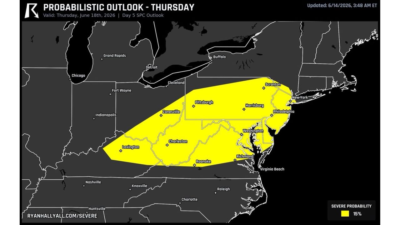
The Day 5 SPC probabilistic outlook updated June 14 at 3:48 AM ET shows a 15 percent severe probability zone in yellow stretching from Zanesville and Lexington through Pittsburgh, Charleston, Harrisburg, Roanoke, and into Philadelphia, Washington, and Richmond. The risk area has nudged east compared to earlier outlooks and is now firmly centered over Pennsylvania, West Virginia, and Virginia.
The yellow shading extends from the Ohio Valley border near Indianapolis and Fort Wayne all the way to the New York and New Jersey coastline, covering a broad swath of the Mid-Atlantic and central Appalachians.
Damaging Wind the Primary Question as Line Pushes Through the Mountains
Forecasters do not expect the storms ahead of Thursday’s system to be strong enough to produce many tornadoes. Instead, the real question centers on damaging wind potential as a line of storms moves through the mountains and into the Mid-Atlantic region covering Pennsylvania, West Virginia, and Virginia.
The mountainous terrain across Pennsylvania and West Virginia could influence how the line evolves as it tracks eastward toward the more populated corridor including Harrisburg, Philadelphia, Washington, and Richmond.
Morning Clouds Could Limit Afternoon Fuel Across Northern Areas
One key uncertainty forecasters are watching is the potential for morning clouds and rain across northern portions of the risk area. If that cloud cover persists, it could rob the atmosphere of afternoon heating fuel needed for storm intensification, which would shrink the overall severe threat across Pennsylvania and points north.
The forecast remains in the process of firming up with several days still remaining before Thursday arrives. Residents across Pennsylvania, West Virginia, and Virginia should continue monitoring updates as confidence in the threat develops.
Stay with GordonRamsayClub.com for the latest updates.

Leave a Reply