
SPRINGFIELD, MISSOURI — A Moderate Risk of flash flooding has been issued for southwest Missouri tonight Saturday June 13, with training thunderstorms expected to repeatedly move over the same areas along a morning storm outflow boundary, producing localized rainfall totals up to 6 inches across Springfield, Joplin, Lebanon, Rolla, and the surrounding Ozarks corridor.
Moderate Flood Risk Bullseye Centered on Springfield and Joplin
The AguaceroWX flash flood risk graphic valid Saturday June 13 shows a Moderate Risk of flooding in red centered directly over Springfield, Joplin, Lebanon, Salem, Ava, and West Plains across southwest Missouri. This is the highest flood risk designation on the map and reflects high forecaster confidence in significant rainfall accumulations across the bullseye zone tonight.
A Slight Risk of flooding in yellow surrounds the Moderate core, extending the elevated flash flood threat outward across Kansas City, Warrensburg, Jefferson City, Rolla, Poplar Bluff, Jonesboro, Fort Smith, Tulsa, and Oklahoma City.
Rainfall Totals of 2 to 4 Inches Expected in the Core Zone
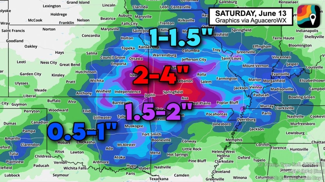
The QPF rainfall graphic shows 2 to 4 inch totals forecast across the Moderate Risk core covering Springfield, Joplin, Lebanon, and the surrounding southwest Missouri corridor. The training storm pattern where repeated cells move over the same areas along the outflow boundary is the primary driver of the localized flooding threat, with isolated amounts potentially reaching 6 inches in the most training-prone locations.
Surrounding areas across the broader Slight Risk zone are forecast to receive 1.5 to 2 inches, with outer areas picking up 0.5 to 1 inch through the overnight period.
Training Storm Pattern Creates Flash Flood Emergency Potential
Morning storms have left behind a stationary boundary across southwest Missouri along which new storm development will repeatedly fire and propagate southeast tonight. This training pattern is particularly dangerous for flash flooding because each successive storm adds rainfall to already saturated ground across the same communities.
Residents across Springfield, Joplin, and the southwest Missouri Ozarks should avoid low-lying areas, never drive through flooded roadways, and monitor flash flood warnings closely through Saturday night.
Stay with GordonRamsayClub.com for the latest updates.

Leave a Reply