
ST. LOUIS, MISSOURI — Monday April 27 was continuing to look like a significant severe weather event across the Illinois, Missouri and broader Mississippi Valley region, with widespread severe weather including a risk for a couple of strong tornadoes likely during the afternoon and into the overnight hours.
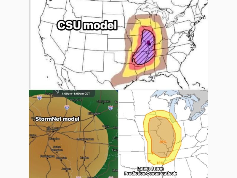
The Storm Prediction Center outlook showed a 30 percent tornado probability at the core of the risk zone, with the CSU model depicting a high-end severe weather setup across the central Mississippi Valley corridor. Timing was expected to run from late afternoon through early Tuesday morning, with eastern portions of the area facing an overnight threat window.
Strong Tornadoes and Widespread Damaging Winds Possible Monday Afternoon Into Overnight
Forecasters identified two primary threats for Monday’s severe weather event. If storms remained cellular in nature, the tornado risk would increase markedly, with a couple of strong tornadoes considered likely across the core risk zone. If storms organized into a line instead, widespread damaging winds would become the dominant and most impactful hazard across the region.
The CSU model showed the highest risk concentrated across a corridor covering Illinois, western Kentucky, Tennessee, and the Mississippi Valley, with the core purple hatched zone indicating the area of greatest tornado concern sitting over central Illinois southward through Missouri and into the mid-South.
SPC Outlook Shows 30 Percent Tornado Probability — Core Risk Over Illinois and Mississippi Valley
The latest Storm Prediction Center outlook showed a 30 percent tornado probability within the core orange risk zone, with a surrounding 15 percent tornado probability zone extending the threat outward across a broader area covering portions of Missouri, Illinois, Kentucky, Tennessee, and neighboring states. The StormNet model showed widespread storm coverage developing between 1 PM and 1 AM CDT across the St. Louis, Mount Vernon, Effingham, and Jackson corridor, confirming the broad geographic footprint of the Monday severe weather setup.
Timing Late Afternoon Through Early Tuesday Morning — Overnight Threat for Eastern Areas
The severe weather window was expected to begin during the late afternoon hours Monday and extend through early Tuesday morning. Forecasters specifically warned that communities further east within the risk zone faced the possibility of an overnight severe weather event, which historically presents greater danger due to reduced public awareness during sleeping hours.
Additional forecast details were expected to become clearer within the next 48 hours as models refined the storm mode and track of the Monday severe weather system across the Mississippi Valley region. Stay with GordonRamsayClub.com for the latest weather updates and detailed forecast coverage.

Leave a Reply