
ABERDEEN, SOUTH DAKOTA — A significant severe weather threat is underway across the Northern Plains this Thursday June 4, 2026, as the WTUS Live Weather Severe Outlook issued at 9:00 AM CDT shows a Level 2 Slight Risk zone centered over a broad corridor from Miles City and Rapid City through Aberdeen and stretching toward Minneapolis, with large hail as the primary threat and damaging winds and tornadoes also possible as storms grow upscale late this evening.
Slight Risk Zone Covers Rapid City Through Aberdeen and Minneapolis Corridor
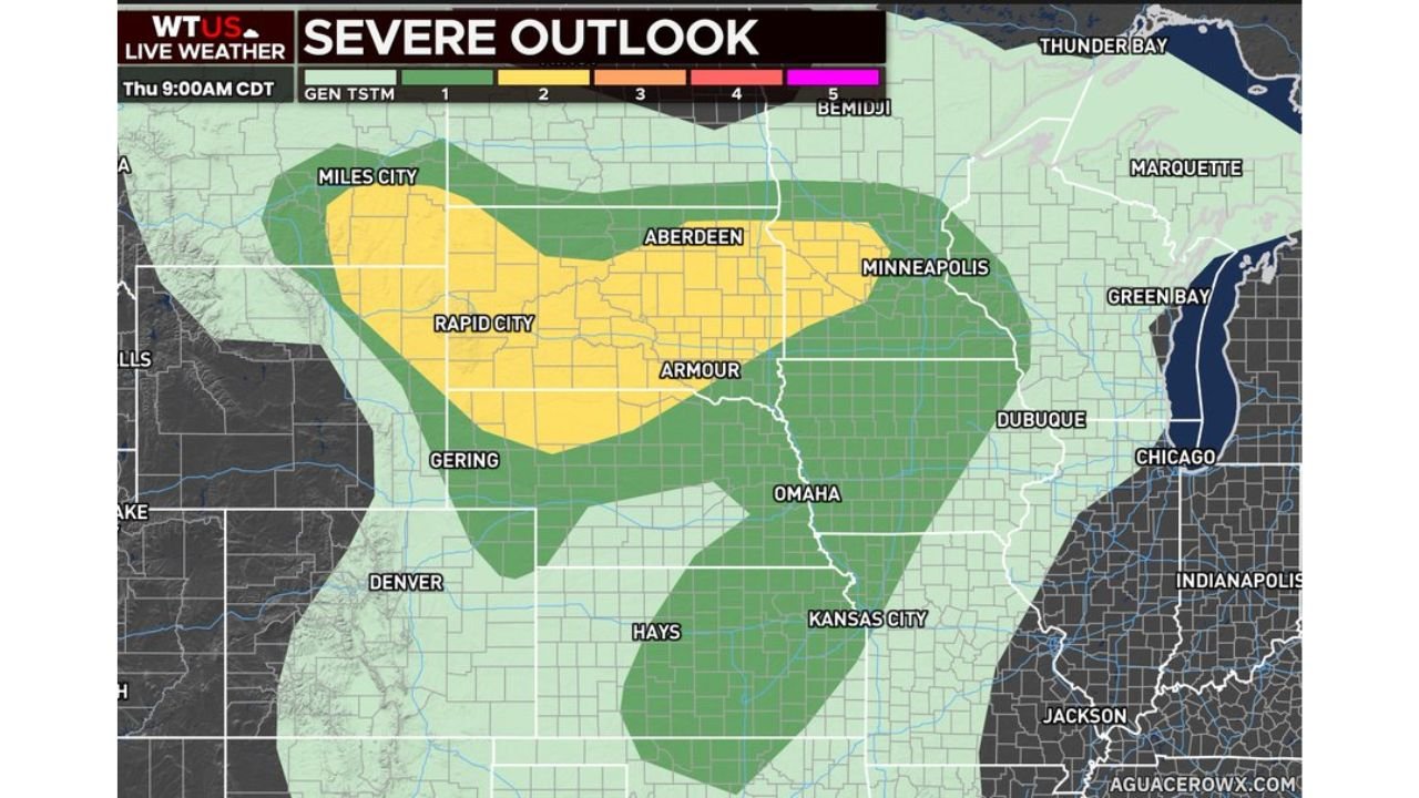
The AguaceroWX Severe Outlook for Thursday June 4 at 9:00 AM CDT shows a well-defined Slight Risk Level 2 zone covering a large swath of the Northern Plains stretching from Miles City in eastern Montana through Rapid City and Armour in South Dakota eastward through Aberdeen and toward Minneapolis in Minnesota. A broader Marginal Risk area extends the overall threat southward through Omaha and Kansas City and eastward toward Dubuque and Chicago, indicating widespread storm coverage across the central United States through Thursday afternoon and evening.
Large Hail Is Primary Threat with Damaging Winds and Tornadoes Also Possible
Large hail is identified as the main hazard driving the Slight Risk designation across the Northern Plains today, consistent with the supercell environment in place across the region. However forecasters are also noting that damaging winds will be possible across the threat zone, with the greatest wind threat expected to arrive after storms grow upscale and organize into a more linear configuration late this evening. A couple of tornadoes will also be possible during the afternoon hours before the upscale storm growth transition occurs, making all three primary severe weather hazards a concern across the Slight Risk corridor today.
Greatest Damaging Wind Threat Arrives After Storms Grow Upscale Late Evening
The timing evolution of today’s severe weather setup is a key factor for residents to understand across the Northern Plains. Large hail and tornado potential will be most prominent during the afternoon hours while discrete supercell mode dominates the storm structures. As the evening progresses and storms consolidate and grow upscale into a more organized convective system, the threat profile will shift toward damaging wind gusts becoming the dominant hazard across the region through the overnight hours.
Residents Across the Dakotas and Surrounding Areas Should Remain Alert All Day
With severe weather possible from this afternoon through late evening across the Northern Plains Slight Risk zone, residents from Miles City and Rapid City through Aberdeen, Armour, and toward Minneapolis should have multiple weather alert methods active throughout Thursday and be prepared to seek shelter immediately when warnings are issued in their area.
Stay with GordonRamsayClub.com for the latest updates.

Leave a Reply