
DES MOINES, IOWA — Strong to severe thunderstorms are possible across parts of Iowa later this afternoon and tonight Thursday June 4, 2026, as the ISCN Weather Severe Weather Outlook shows a Slight Risk zone covering western and portions of central Iowa with a broader Marginal Risk extending across the remainder of the state, bringing large hail, damaging wind gusts, isolated tornado potential, and localized flash flooding threats to the region.
Slight Risk Covers Western Iowa as Greatest Threat Targets Western, Central, and Southern Zones
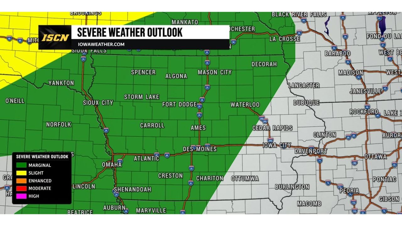
The ISCN Weather Severe Weather Outlook for Thursday June 4 shows a Slight Risk zone concentrated across western Iowa near Sioux City, Storm Lake, Carroll, Atlantic, Shenandoah, and surrounding communities, with the Marginal Risk covering the broader central and southern Iowa corridor including Fort Dodge, Ames, Des Moines, Creston, Chariton, and Ottumwa. The greatest overall risk for severe weather today appears focused across western, central, and southern Iowa where a few storms could become severe as they move through the state during the afternoon and evening hours.
Large Hail, Damaging Wind Gusts, Isolated Tornado, and Flash Flooding All Possible
Today’s severe weather setup carries a full suite of hazards across the Iowa threat zone. Large hail, damaging wind gusts, and an isolated tornado are all possible from any storm that develops and intensifies this afternoon and evening. Additionally, heavy rainfall with localized flash flooding is highlighted as a concern, particularly for communities in low-lying areas and near streams across western, central, and southern Iowa. Forecasters note that while not everyone will see severe weather today, any storm that develops must be monitored very closely given the volatile environment in place.
Storm Development Expected During Afternoon Hours with Threat Continuing Tonight
Storm initiation is expected during the afternoon heating hours with the severe weather threat continuing through the evening and into tonight across Iowa. The threat corridor stretches from the Nebraska border near Omaha and Lincoln eastward through Des Moines and toward the Iowa City and Davenport areas, indicating a broad window of storm coverage possible across the state through the overnight period.
Iowa Residents Should Have Multiple Alert Methods Active Before Storms Develop
With large hail, damaging winds, tornado potential, and flash flooding all possible this afternoon and evening, residents across western, central, and southern Iowa should ensure weather alert notifications are active on their devices and have shelter plans ready well before storm development begins Thursday afternoon.
Stay with GordonRamsayClub.com for the latest updates.

Leave a Reply