
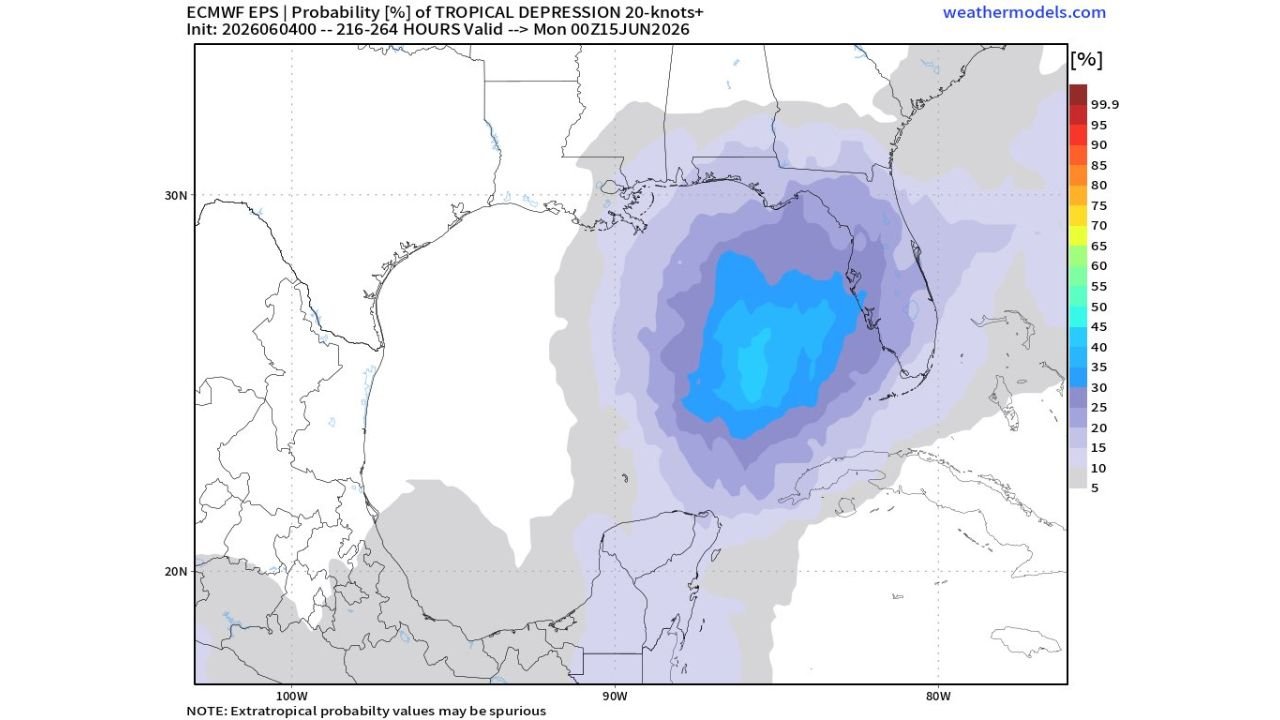
MIAMI, FLORIDA — A growing tropical weather signal is emerging over the Gulf of Mexico and Florida region for late next week, as ECMWF EPS ensemble probability data initialized June 4, 2026 and valid Monday June 15, 2026 at 00Z shows tropical depression level development probabilities of 35 to 55 percent concentrated over the eastern Gulf of Mexico and Florida peninsula, with Caribbean moisture surging northward as the primary fuel source for potential development.
ECMWF EPS and Google DeepMind AI Both Flagging Tropical Signal for Gulf Around June 15
The growing tropical concern is being supported by two highly regarded forecast tools simultaneously. The ECMWF European ensemble suite, one of the most reliable long-range forecast models globally, is showing a meaningful tropical depression probability signal centered over the eastern Gulf of Mexico and Florida valid around June 15, 2026. Additionally, Google DeepMind AI, described as having been exceptional across the past three hurricane seasons, is also flagging the same tropical signal for the Gulf region during the late next week timeframe. The agreement between these two independent and reliable forecast systems adds credibility to the emerging tropical development concern.
Tropical Depression Probability of 35 to 55 Percent Concentrated Over Eastern Gulf and Florida
The ECMWF EPS tropical depression probability map shows a core zone of 35 to 55 percent probability covering the eastern Gulf of Mexico and extending over the Florida peninsula, with surrounding probabilities of 15 to 30 percent spreading across a broader area of the central and western Gulf. The probability footprint is centered roughly between the Florida coastline and the Yucatan Peninsula, indicating the eastern Gulf as the most likely zone for any tropical development or organization during the June 15 window.
Any Development Likely Weak and Lopsided Due to Wind Shear and Dry Air in June
Forecasters are cautioning that even if tropical development occurs in the Gulf around June 15, the early June season environment typically features significant wind shear and dry air intrusion that would likely keep any system weak and disorganized. Any tropical feature that spins up would likely be a weak and lopsided rain-maker rather than a well-organized tropical storm. The first name on the 2026 Atlantic hurricane season list is Arthur, which would be assigned to the first named storm if development reaches tropical storm strength.
Gulf Coast and Florida Residents Should Monitor Tropical Forecasts Through Mid-June
While the tropical signal for the Gulf around June 15 remains at the early monitoring stage, residents across the Gulf Coast from Texas through Florida should begin tracking official National Hurricane Center tropical weather outlooks as the June 15 window approaches and forecasters refine the development potential over the coming days.
Stay with GordonRamsayClub.com for the latest updates.

Leave a Reply