
KANSAS CITY, MISSOURI — Multiple lines of severe storms are forecast to sweep through the central United States Saturday night June 13, with the greatest threat concentrated across Kansas, Missouri, and Illinois where large hail, significant damaging winds, and a few tornadoes will all be possible as the HRRR future radar valid at 8PM ET shows an expansive multi-line storm complex stretching from Wisconsin to Texas.
HRRR Future Radar Shows Two Distinct Storm Lines at 8PM Saturday
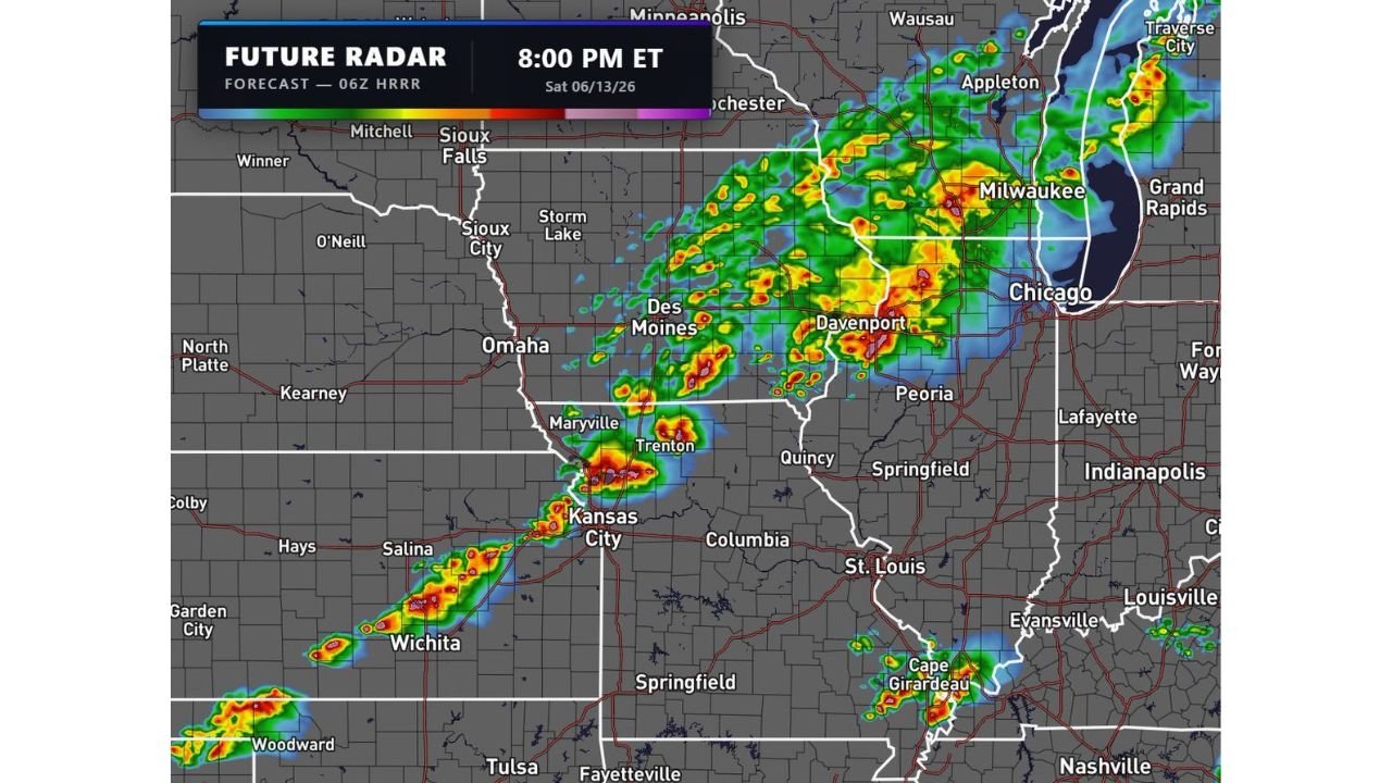
The 06z HRRR future radar valid Saturday June 13 at 8PM ET shows two organized lines of severe storms developing simultaneously across the central plains and upper Midwest. The northern line stretches from Sioux Falls and Sioux City through Des Moines, Davenport, and into the Chicago and Milwaukee corridor with intense red and yellow radar returns indicating heavy precipitation and strong storm activity.
The southern line extends from Wichita and Salina through Kansas City, Maryville, and Trenton with the most intense storm cores concentrated near the Kansas City metro and the surrounding Missouri corridor.
Greatest Threat Centered on Kansas City Missouri and Illinois Corridor
Forecasters are identifying Kansas, Missouri, and Illinois as the highest threat zone Saturday night, where the combination of large hail, significant damaging winds, and a few tornadoes are all on the table. The Kansas City metro sits directly between the two storm lines making it one of the most closely watched locations for Saturday night’s event.
Peoria, Quincy, Springfield, and Davenport also fall within the elevated threat corridor as the storm lines push eastward through the evening hours.
Storm Lines Stretch From Wisconsin to Texas Saturday Night
The full extent of Saturday night’s severe weather corridor stretches from the upper Midwest all the way through the southern plains toward Tulsa, Woodward, and the Oklahoma and Texas border region. Communities across this entire stretch from Wisconsin southward through Missouri and Kansas into northern Oklahoma should remain weather-aware through Saturday evening and night.
Residents across the greatest threat zone are urged to have multiple warning methods active before Saturday night arrives.
Stay with GordonRamsayClub.com for the latest updates.

Leave a Reply