
CHARLOTTE, NORTH CAROLINA — A hot and humid Friday is setting the stage for potential strong to severe storm development across the Carolinas and surrounding region this evening, with an MCS outflow boundary tracking southward from Kentucky and Tennessee serving as the key trigger question for late day storm chances across North Carolina, South Carolina, and adjacent areas.
Outflow Boundary Tracking South Toward the Carolinas This Morning
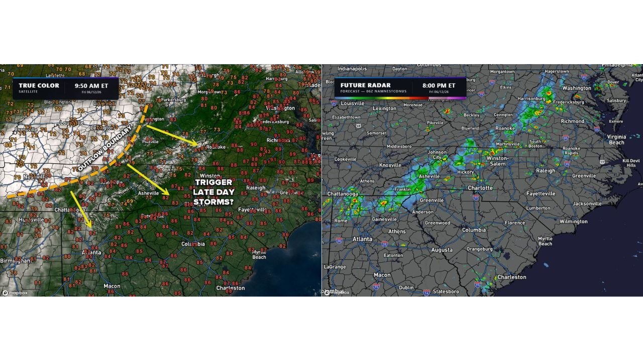
True color satellite imagery valid 9:50 AM ET Friday June 12 shows an outflow boundary draped from Lexington Kentucky southwestward through Pikeville, Asheville, and into the Chattanooga corridor. The boundary is the primary focus for afternoon storm initiation across the region as it interacts with an exceptionally hot and humid surface air mass beneath it.
Forecasters are flagging whether this outflow boundary will provide enough of a lifting trigger to fire strong or even severe storms by the evening hours across North Carolina and the surrounding Carolinas region.
Future Radar Shows Storm Clusters Developing by 8PM Along the Mountains
The 06z NAMNESTCONUS future radar valid 8PM ET Friday June 12 shows storm clusters developing along the mountain corridors near Asheville, Johnson City, Hickory, and Winston-Salem by early evening. Additional storm activity is indicated near Roanoke, Harrisonburg, and Fredericksburg further northeast along the Appalachian corridor.
The storm coverage appears focused along and near the mountain terrain where outflow boundary interactions and afternoon heating will be most effective at triggering convection.
Super Hot and Humid Air Mass Provides Ample Storm Fuel
Surface temperatures and dewpoints across the Carolinas today are running exceptionally high, providing abundant instability fuel for any storms that can successfully initiate along the outflow boundary. The big uncertainty remains whether the trigger will be sufficient given that other atmospheric factors are not as favorable for widespread storm development.
Residents across Charlotte, Asheville, Winston-Salem, and the surrounding Carolinas should monitor evening forecasts closely and be prepared for rapidly developing storms through the Friday evening hours.
Stay with GordonRamsayClub.com for the latest updates.

Leave a Reply