
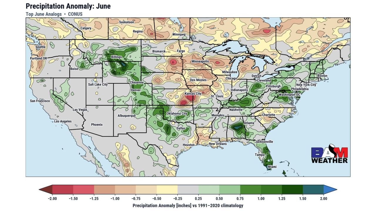
KANSAS CITY, MISSOURI — Top historical analogs for June 2026 are painting a clear and divided precipitation picture across the United States, with BAM Weather’s June Precipitation Anomaly map based on top June analogs showing a continued drier than normal pattern setting up across the Upper Midwest and Great Plains while the subtropical jet stream continues to funnel moisture into the South and Southeast.
Upper Midwest and Great Plains Facing Drier Than Normal June According to Top Analogs
The most notable signal on the June analog precipitation anomaly map is the broad area of below-normal precipitation anomaly values depicted across the Upper Midwest and Great Plains corridor. The tan and light brown shading covering Minnesota, Wisconsin, Iowa, Nebraska, the Dakotas, and Kansas indicates analog-based precipitation anomalies running 0.25 to 0.75 inches below normal for the month of June.
This drier than normal signal across the northern plains and upper Midwest has important implications for agricultural interests, water supply, and drought development across a region that has already seen variable moisture over recent weeks. Fargo, Minneapolis, Des Moines, and Kansas City all sit within or near this below-normal precipitation footprint heading into June.
Subtropical Jet Stream Continues Feeding Above Normal Moisture Into the South and Southeast
In sharp contrast to the drier signal across the north, the subtropical jet stream is clearly depicted on the analog map as a conduit of above-normal moisture flowing into the South and Southeast for June. Green shading indicating positive precipitation anomalies of 0.50 to 1.50 inches above normal is concentrated across Texas, Oklahoma, Arkansas, Louisiana, Mississippi, Tennessee, and the Carolinas.
This continued above-normal moisture signal for the South aligns with the active and wet pattern that has already been in place across the region through late May, suggesting the wet and unsettled conditions across the Deep South are not simply a short-term event but rather part of a broader atmospheric pattern expected to persist well into June.
Pacific Northwest and Northern Rockies Also Showing Pockets of Above Normal Precipitation
The analog map also shows isolated pockets of above-normal precipitation anomaly values across the Pacific Northwest and northern Rockies region, with green shading visible near Billings and portions of Montana and Idaho. These areas stand out as localized exceptions to the broadly drier signal that dominates the upper tier of the country in the June analog composite.
Residents across the Upper Midwest and Great Plains should prepare for a potentially drier than normal June while the South and Southeast brace for continued above-normal rainfall through the month.
Stay with GordonRamsayClub.com for the latest updates.

Leave a Reply