
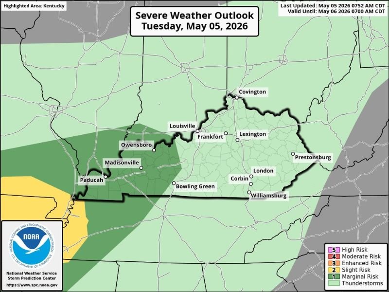
WESTERN KENTUCKY — The Storm Prediction Center has placed Western Kentucky under a 1 out of 5 Marginal severe weather risk for Tuesday evening, May 5, 2026, with isolated damaging wind gusts and a 2% tornado risk both active across the outlined zone. The outlook was last updated May 5, 2026 at 7:52 AM CDT and remains valid through May 6, 2026 at 7:00 AM CDT, covering a corridor that includes Paducah, Madisonville, and Owensboro in the western portion of the state.
What the Marginal Risk Means for Western Kentucky
A Marginal 1 of 5 risk is the lowest level on the SPC severe weather scale, indicating that severe weather is possible but not expected to be widespread or particularly organized across the affected area. For Western Kentucky, the primary hazards tied to this evening’s risk are isolated damaging wind gusts and a low 2% tornado probability that cannot be completely dismissed despite the limited overall threat level.
Meteorologists monitoring the situation noted they are not seeing a particularly strong signal for severe weather development this evening, but shared the SPC outlook to ensure residents across the region remain informed and aware heading into the evening hours.
Areas Inside the Risk Zone
The Marginal risk zone covers the western portion of Kentucky, with Paducah sitting near the higher end of the threat area where a Slight risk zone borders the Marginal zone. Madisonville and Owensboro also fall within the outlined area, along with surrounding communities across western Kentucky that could see isolated storm activity during Tuesday evening.
The far western tip of Kentucky near Paducah sits closest to the Slight risk zone extending from neighboring states, meaning that area carries a marginally higher level of concern compared to communities sitting deeper inside the Marginal zone.
Rest of Kentucky Outlook
Much of central and eastern Kentucky including Louisville, Frankfort, Lexington, Bowling Green, and Covington falls within the general thunderstorm zone on Tuesday’s outlook map, indicating that storm activity is possible across the broader state without the same level of organized severe weather concern that applies to the western counties under the Marginal risk designation.
What Western Kentucky Residents Should Do
Residents across Paducah, Madisonville, Owensboro, and surrounding western Kentucky communities are advised to stay weather aware during Tuesday evening hours. While the overall threat level is low, isolated damaging wind gusts and a brief tornado remain possible and warrant monitoring of local weather alerts throughout the evening. Stay with GordonRamsayClub.com for the latest updates.

Leave a Reply