
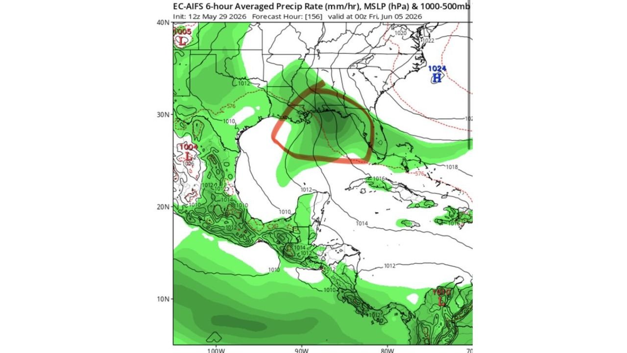
MIAMI, FLORIDA — Tropical interests are being watched closely across the Gulf of Mexico and Florida this weekend, with the EC-AIFS model initialized at 12z May 29, 2026 showing a small but notable chance of subtropical or tropical storm development in the middle Gulf, with forecast hour 156 valid at 00z Friday June 5, 2026 depicting a 1000 mb low pressure center circled in the northern Gulf region that has drawn attention from meteorologists tracking the pattern.
EC-AIFS Model Shows 1000 MB Low in Northern Gulf With Subtropical Development Signal
The EC-AIFS 6-hour averaged precipitation rate and MSLP forecast valid at 00z June 5, 2026 shows a closed 1000 mb low pressure center positioned in the northern Gulf of Mexico, outlined by a hand-drawn red and brown circle on the forecast map highlighting the area of interest. The surrounding 1010 and 1012 mb isobars and the precipitation shading in green across the Gulf region indicate an organized moisture and circulation pattern developing within this zone that both the Euro AI and AIFS models are picking up on as having at least a small chance of subtropical or tropical storm development.
A separate 1005 mb low is also visible on the upper left portion of the EC-AIFS map near the northern Gulf Coast, adding additional complexity to the overall Gulf pattern heading into early June.
Drought Stricken Florida Hoping for Heavy Rains From Sheared Moisture Next Week
For drought-stricken Florida, the potential for heavy rainfall next week represents a critically needed development regardless of whether any formal tropical or subtropical system organizes in the Gulf. Forecasters note that even under a sheared scenario where the Gulf disturbance fails to consolidate into a named system, the moisture associated with the pattern could still deliver significant and beneficial rainfall across the Florida peninsula next week.
The upper right panel of the model output shows green precipitation shading extending across the Florida peninsula and surrounding waters, suggesting meaningful rainfall potential for the state even in the absence of a fully organized tropical system.
Euro AI and AIFS Models Both Hinting at Gulf Development but Confidence Remains Low
Both the Euro AI and AIFS models are hinting at the Gulf development scenario for the June 4 to 5 timeframe, giving the signal at least multi-model backing that elevates it above a single-model outlier. However forecasters are careful to characterize the development probability as small, acknowledging the significant uncertainty that remains at this forecast range and the tendency for Gulf disturbances to struggle with organization under sheared atmospheric conditions.
Residents across Florida and the Gulf Coast should monitor tropical forecasts closely through next week as this system’s potential development and moisture impact becomes clearer.
Stay with GordonRamsayClub.com for the latest updates.

Leave a Reply