
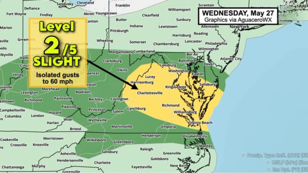
WASHINGTON, D.C. — A potentially impactful weather setup is unfolding across the Mid-Atlantic region today Wednesday May 27, 2026, as a frontal boundary sagging southward encounters a humid and juiced-up air mass, producing a multi-hazard threat across Maryland, Washington D.C., and Virginia that includes isolated strong thunderstorm gusts up to 60 mph and active Flood Watch conditions, according to AguaceroWX graphics issued for today.
Level 2 Slight Risk With Isolated Gusts to 60 MPH Active Across Maryland, DC and Virginia
The severe weather outlook for Wednesday May 27 shows a Level 2 out of 5 Slight Risk zone covering a corridor across Maryland, Washington D.C., Virginia, and extending into portions of West Virginia and Delaware. Isolated thunderstorm gusts reaching up to 60 mph are the primary wind threat within this zone, capable of downing trees, snapping power lines, and creating dangerous driving conditions across the densely populated Mid-Atlantic corridor.
The instability and storm fuel map for today shows significant SBCAPE values loaded across the Mid-Atlantic and mid-Atlantic Piedmont region, with elevated instability providing the energy source for storms capable of producing these damaging wind gusts as the frontal boundary pushes through the area.
Flood Watch in Effect Across the Region as Repetitive Downpours Threaten Isolated Flooding
Alongside the wind threat, a Flood Watch is active across a broad area of the Mid-Atlantic as shown on the Wednesday May 27 AguaceroWX flood map. The combination of a humid and moisture-rich air mass running into the frontal boundary is setting up conditions favorable for repetitive rounds of heavy downpours capable of producing isolated flooding across the region.
Forecasters specifically note that for the broader Midwest, repetitive rounds of downpours will lead to isolated flooding, while the Maryland, D.C., and Virginia corridor faces the additional threat of isolated strong thunderstorm gusts on top of the flooding concern.
Humid and Unstable Air Mass Providing Abundant Storm Fuel Across the Corridor
The dewpoint and humidity map for today shows a deeply humid air mass labeled clearly across the Mid-Atlantic and Ohio Valley region, with the moisture and instability combination providing abundant storm fuel for any convective development along and ahead of the frontal boundary today.
Residents across Maryland, Washington D.C., Northern Virginia, and surrounding areas should monitor warnings closely, secure any loose outdoor items, and avoid flood-prone roads throughout the day as the frontal system moves through the region.
Stay with GordonRamsayClub.com for the latest updates.

Leave a Reply