
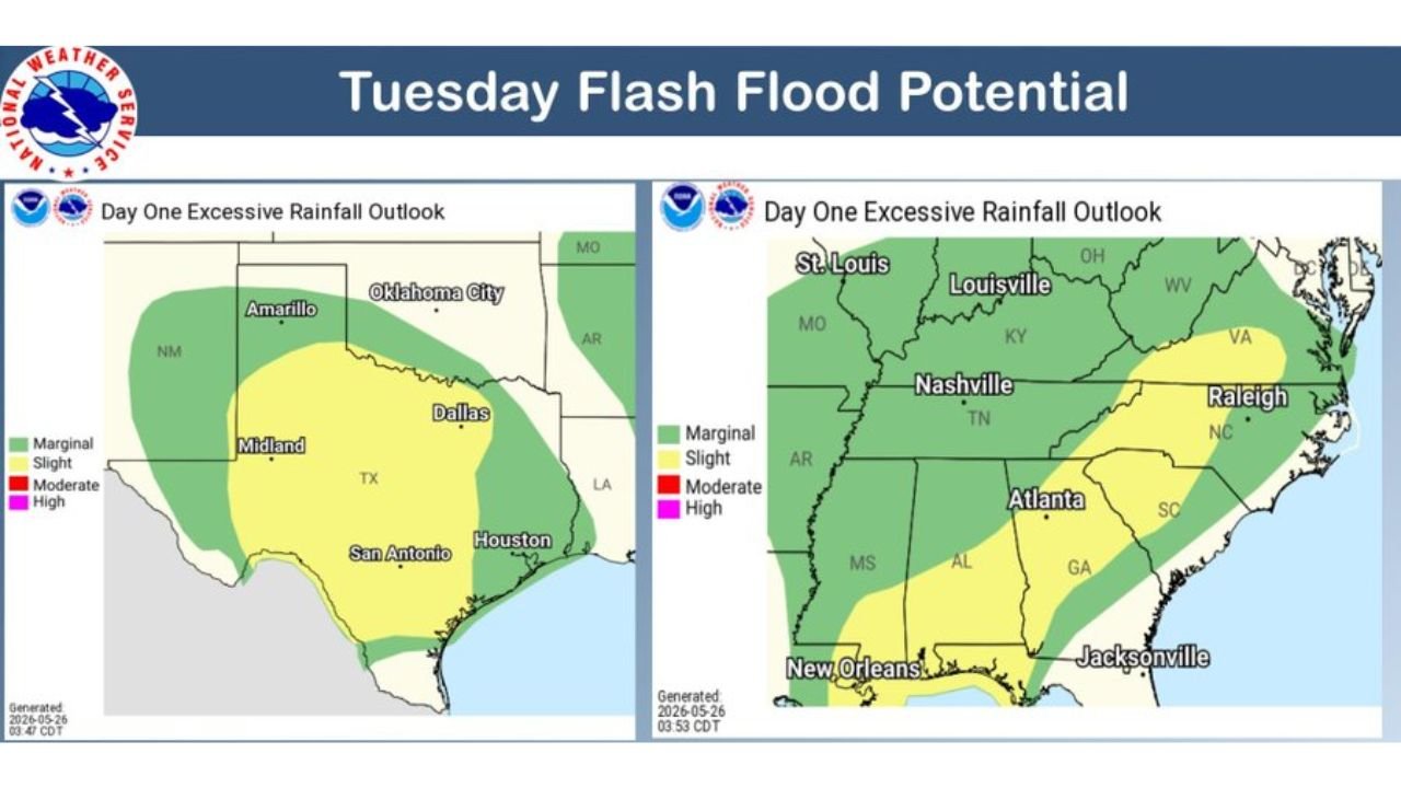
SAN ANTONIO, TEXAS — The National Weather Service Weather Prediction Center has issued its Tuesday Flash Flood Potential outlook at 5:03 AM EDT on May 26, 2026, placing Slight Risk zones across two separate and significant regions of the country — a large portion of Texas including the sensitive Hill Country region, and a broad swath of the Southeast stretching from Nashville through Raleigh — as moisture continues to stream in from the Gulf Coast to the Appalachians.
Slight Risk of Excessive Rainfall Covers Dallas, San Antonio, Houston and Texas Hill Country
The western Day One Excessive Rainfall Outlook shows a yellow Slight Risk zone blanketing a massive portion of Texas, covering Dallas, San Antonio, Houston, Midland, and Amarillo within its boundaries. The Hill Country region sitting between San Antonio and the broader central Texas corridor is specifically flagged as a sensitive area where a complex of storms could bring locally heavy rainfall capable of triggering rapid flash flooding.
The Hill Country is particularly vulnerable to flash flooding due to its rocky terrain, steep drainage gradients, and shallow soil that allows water to run off rapidly rather than absorbing into the ground. Even modest rainfall totals in this region can produce dangerous and life-threatening flash flood conditions in a very short period of time.
Slight Risk Extends From Nashville and Atlanta Through Raleigh Across the Southeast
The eastern Day One Excessive Rainfall Outlook shows a separate Slight Risk zone covering a wide corridor of the Southeast, with Nashville, Tennessee, Atlanta, Georgia, and Raleigh, North Carolina all sitting within the yellow Slight Risk shading. This zone reflects the ongoing moisture streaming in from the Gulf Coast pushing northeastward through the Appalachian region.
A broader Marginal Risk zone surrounds the Slight Risk area and extends further north through Louisville, Kentucky, St. Louis, Missouri, and southward through New Orleans and Jacksonville, keeping a large multi-state area within the flash flood threat footprint for today.
Gulf Coast to Appalachians Facing Continued Scattered Flash Flooding as Moisture Streams In
Forecasters note that the Gulf Coast to Appalachian corridor may continue to see scattered flash flooding events today as moisture continues to stream persistently into the region. The wet pattern shows no signs of breaking, with another day of heavy rainfall potential keeping flash flood concerns active from Texas all the way to the Carolina coastline.
Residents across both Slight Risk zones should avoid flood-prone roads, monitor local warnings closely, and never attempt to drive through water-covered roadways today.
Stay with GordonRamsayClub.com for the latest updates.

Leave a Reply