
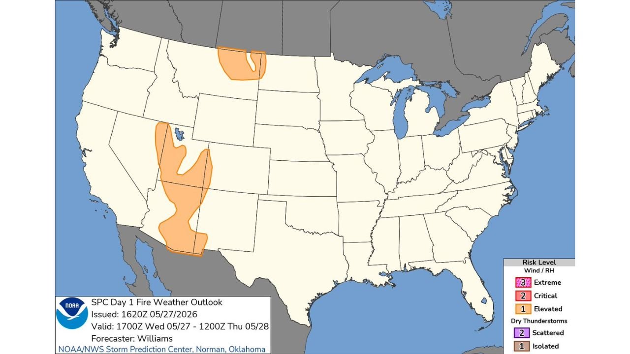
RENO, NEVADA — The Storm Prediction Center has issued its Day 1 Fire Weather Outlook at 1620Z on May 27, 2026, placing Elevated fire weather risk zones across two distinct regions of the western United States — a large swath covering Nevada and Utah on the southern end and a separate zone across northern Montana — with the outlook valid from 1700Z Wednesday May 27 through 1200Z Thursday May 28, 2026, as issued by forecaster Williams.
Elevated Fire Weather Risk Covers Broad Nevada and Utah Corridor
The most expansive Elevated fire weather risk zone on today’s outlook stretches across a wide area of Nevada and into portions of Utah, with the orange shading covering a significant portion of the Great Basin region. This zone represents a Level 1 out of 3 designation on the fire weather risk scale, indicating that a combination of low relative humidity, dry fuels, and wind conditions are coming together to create an environment where any ignition could spread rapidly.
The Nevada and Utah corridor is particularly susceptible to fire weather conditions this time of year as vegetation dries out heading into summer and wind events become more frequent across the Great Basin landscape. Residents, ranchers, and outdoor workers across this zone should avoid any open burning and exercise extreme caution with any potential ignition sources through Thursday.
Separate Elevated Zone Outlined Across Northern Montana Near the Canadian Border
A second distinct Elevated fire weather risk zone is depicted across northern Montana near the Canadian border on today’s SPC Fire Weather Outlook. This northern zone is geographically separate from the Nevada and Utah threat and reflects a different set of atmospheric conditions driving elevated fire weather potential across the northern Rockies and high plains border region.
The Montana zone sits in a portion of the country where dry and windy conditions can develop rapidly during late May, creating dangerous fire spread potential particularly in grassland and rangeland areas across the northern tier of the state.
No Critical or Extreme Fire Weather Designations Active Anywhere in the Country Today
Importantly, today’s SPC Day 1 Fire Weather Outlook carries no Critical Level 2 or Extreme Level 3 fire weather designations anywhere across the continental United States. The Elevated Level 1 zones in Nevada, Utah, and Montana represent the highest fire weather risk active on the national map today, meaning conditions while concerning do not rise to the most dangerous thresholds at this time.
Residents across all Elevated zones should remain vigilant and report any smoke or fire immediately to local authorities.
Stay with GordonRamsayClub.com for the latest updates.

Leave a Reply