
SPRINGFIELD, ILLINOIS — A decaying line of storms was forecast to move into Illinois from the west after midnight Thursday night and push eastward in a weakening state through Friday morning, bringing 60 to 70 percent storm coverage and gusty winds up to 55 mph across the region. The overall severe risk remained marginal and low, with tornado risk classified as very low and forecasters confirming it was safe to go to bed Thursday night without significant concern across the affected zones.
Decaying Squall Line Arrives After Midnight — Moving East in Weakening State
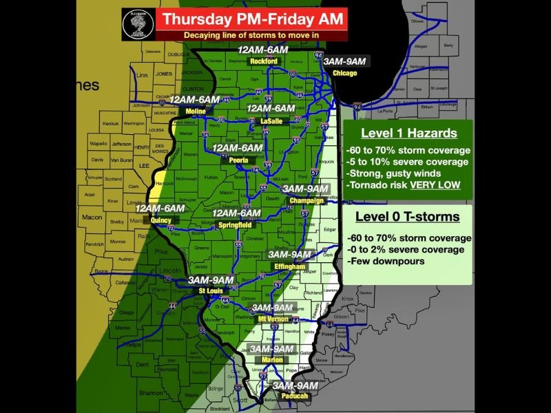
The storm system was described as a decaying squall line, meaning it was already losing organizational strength as it approached from the west. The line was expected to move in after midnight and track eastward across Illinois in a progressively weakening state through the early Friday morning hours.
Despite the weakening nature of the system, gusty winds up to 55 mph could not be ruled out ahead of and within the line, making wind the primary hazard associated with the overnight event across the Illinois coverage zone.
Timing Breakdown Across Illinois — Midnight to 6 AM for Western Zones
The arrival timing varied significantly from west to east across the state. The midnight to 6 AM window covered the western Illinois corridor including Moline, LaSalle, Peoria, Springfield, and Quincy as the line pushed in from the west first. The 3 AM to 9 AM window applied to eastern and southern communities including Champaign, Effingham, St. Louis, Mt. Vernon, Marion, and Paducah, with Chicago seeing the line arrive between 3 AM and 9 AM as well given its position along the eastern edge of the state.
Level 1 Hazards for Northern and Central Illinois — Level 0 Thunderstorms for Southern Zone
The northern and central Illinois zone fell under Level 1 Hazards, carrying 60 to 70 percent storm coverage, 5 to 10 percent severe coverage, strong gusty winds, and a very low tornado risk. Southern Illinois communities fell under Level 0 Thunderstorms, with 60 to 70 percent storm coverage, only 0 to 2 percent severe coverage, and a few downpours as the primary impact.
Forecasters across the Illinois Storm Community confirmed the overall severe risk was low and residents across the entire affected zone were safe to sleep through the overnight storm passage without elevated concern. Stay with GordonRamsayClub.com for the latest weather updates and detailed forecast coverage.
Leave a Reply