
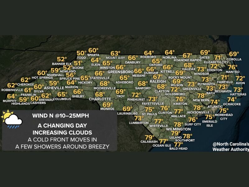
NORTH CAROLINA — A cold front was moving into North Carolina on Sunday April 19, 2026, bringing a dramatic temperature split across the state and breezy north winds between 10 and 25 mph. Western mountain communities were seeing temperatures drop into the 40s and 50s while central and eastern sections held onto warmer readings in the 70s and even some 80s along the coast. Forecasters were also keeping a close eye on the wind given the ongoing drought conditions and wildfire concern across the state.
Sharp Temperature Split — Mountains in the 40s While Coast Reaches 80s
The high temperature map showed a striking contrast from west to east across North Carolina. Mountain communities bore the brunt of the cold front first, with Banner Elk at 51, Boone at 52, and Asheville in the low 60s. Temperatures warmed considerably heading east, with Charlotte and Raleigh both at 68, before the coast surged into the upper 70s with Wilmington at 79 and Calabash reaching 79 degrees.
Temperatures Drop Fast This Morning Then Rebound by Afternoon — Dress in Layers
Forecasters advised residents to dress in layers as temperatures were expected to drop quickly during the morning hours before rebounding through the afternoon. A couple of showers were expected across western North Carolina in the morning, with isolated showers potentially working eastward through the day, though the rain would not be significant enough to make any meaningful dent in the ongoing drought conditions affecting the state.
Winds up to 25 MPH Raise Wildfire Concern Across Drought-Stressed State
North winds of 10 to 25 mph were expected throughout Sunday, with forecasters specifically flagging wildfire risk given the dry conditions across North Carolina. Meteorologists indicated they would be watching closely to ensure the wind did not knock down power lines or ignite a wildfire across the drought-stressed landscape statewide. Stay with GordonRamsayClub.com for the latest weather updates and detailed forecast coverage.

Leave a Reply