
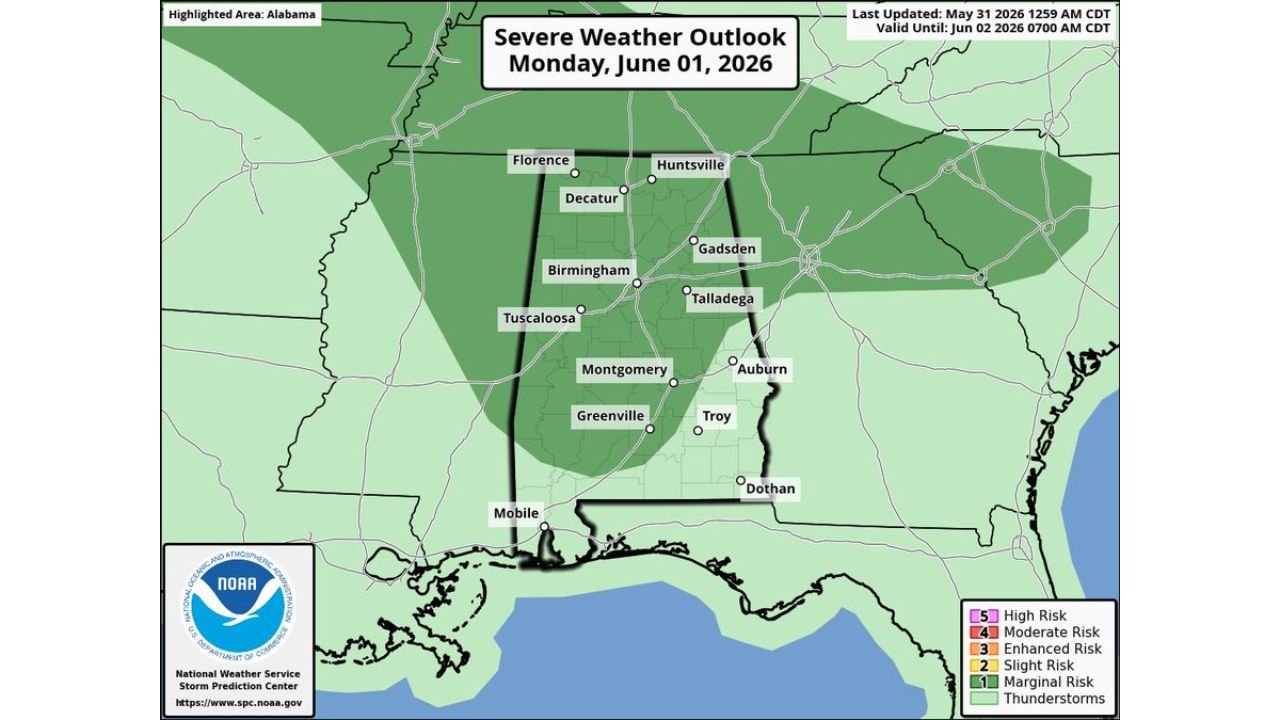
BIRMINGHAM, ALABAMA — A severe weather threat is building across Alabama as Monday, June 1, 2026 approaches, with the Storm Prediction Center issuing a Marginal Risk (Level 1 of 5) outlook covering roughly the northern three-quarters of the state.
SPC Places Northern Three-Quarters of Alabama Under Marginal Risk Outlook
The National Weather Service Storm Prediction Center has issued a Marginal Risk severe thunderstorm outlook valid through June 2, 2026 at 7:00 AM CDT. The highest-risk zone covers a corridor stretching from Florence and Decatur in the north through Birmingham, Tuscaloosa, Montgomery, and Greenville in central Alabama. Huntsville, Gadsden, Talladega, and Auburn also fall within the outlined area. Mobile and the far southern tip of the state sit outside the primary risk zone but remain under a general thunderstorm threat.
Strong Straight Line Winds Are the Primary Concern Monday
High-resolution weather models indicate an organized batch of showers and storms is expected to push into the state during Monday afternoon and evening hours. The main hazard from this system will be strong straight line winds rather than tornadoes. Residents across the affected corridor should prepare for potentially damaging wind gusts accompanying storm cells. Today — Sunday, May 31 — remains warm and humid with scattered afternoon showers, with any single location carrying a 50 to 60 percent chance of rainfall and highs in the mid 80s.
Birmingham Temperatures Stay in the Mid to Upper 80s All Week
NBM model data for Birmingham-Shuttlesworth International Airport shows highs holding between 81°F and 88°F through June 10. Overnight lows dip into the low 60s midweek before climbing back toward the upper 60s by the June 6–7 weekend. Conditions remain seasonably warm with no major temperature swings expected throughout the period.
Drier and Rain Free Conditions Return Wednesday Through the Weekend
After Monday’s threat clears, drier air rolls into Alabama on Tuesday, with any remaining showers isolated to the southern third of the state. Wednesday through Friday looks rain-free statewide with mostly sunny skies, clear nights, and noticeably lower humidity. The upcoming weekend of June 6–7 also appears largely dry at this time.
Stay with GordonRamsayClub.com for the latest updates.

Leave a Reply