
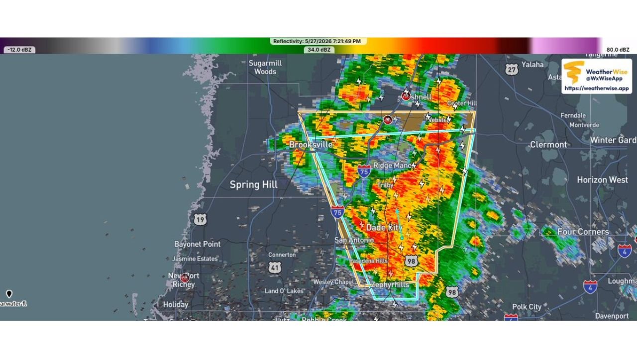
BROOKSVILLE, FLORIDA — The National Weather Service in Ruskin has issued an Immediate Broadcast Severe Thunderstorm Warning at 7:06 PM EDT on Wednesday May 27, 2026, covering Southern Sumter County in central Florida, Eastern Pasco County in west central Florida, and Southeastern Hernando County in west central Florida, with the warning valid until 7:30 PM EDT this evening.
Warning Covers Southern Sumter, Eastern Pasco and Southeastern Hernando Counties
The Severe Thunderstorm Warning polygon as shown on the WeatherWise radar reflectivity map captured at 7:21:49 PM on May 27, 2026 covers a clearly defined zone outlined in yellow and white across the tri-county area. The warned area encompasses communities including Brooksville, Dade City, Ridge Manor, Trilby, San Antonio, Pasadena Hills, and Zephyrhills, placing a densely populated stretch of the Interstate 75 corridor in the direct path of the warned severe thunderstorm complex.
The radar imagery shows intense red, orange, and yellow returns concentrated directly within the warning polygon, with multiple lightning bolt symbols embedded throughout the storm cell indicating active and frequent electrical activity within the severe thunderstorm at the time of the radar scan.
Significant Storm Activity Visible on Radar From Bushnell Through Dade City Corridor
The WeatherWise reflectivity map at 7:21 PM shows the most intense radar returns concentrated in a corridor running from near Bushnell and Webster in the north through Ridge Manor and Trilby and extending south toward Dade City and the Zephyrhills area. The deep red and orange cores indicate the heaviest rainfall and most intense convective activity is tracking through the heart of the warned polygon along the I-75 spine.
Spring Hill, New Port Richey, Land O Lakes, and Wesley Chapel sit along the western and southern edges of the broader storm complex, keeping additional communities in the Tampa Bay metro region on alert for deteriorating conditions as the system moves through the area during the warning period.
Immediate Action Required for All Residents Within the Warning Zone Until 7:30 PM
The NWS Ruskin bulletin carries an Immediate Broadcast designation, meaning all residents, businesses, and travelers within Southern Sumter, Eastern Pasco, and Southeastern Hernando Counties should take immediate shelter in a sturdy building away from windows until the warning expires at 7:30 PM EDT. Outdoor activities should be suspended immediately and all travel through the warned area should be avoided until conditions clear.
Stay with GordonRamsayClub.com for the latest updates.

Leave a Reply