
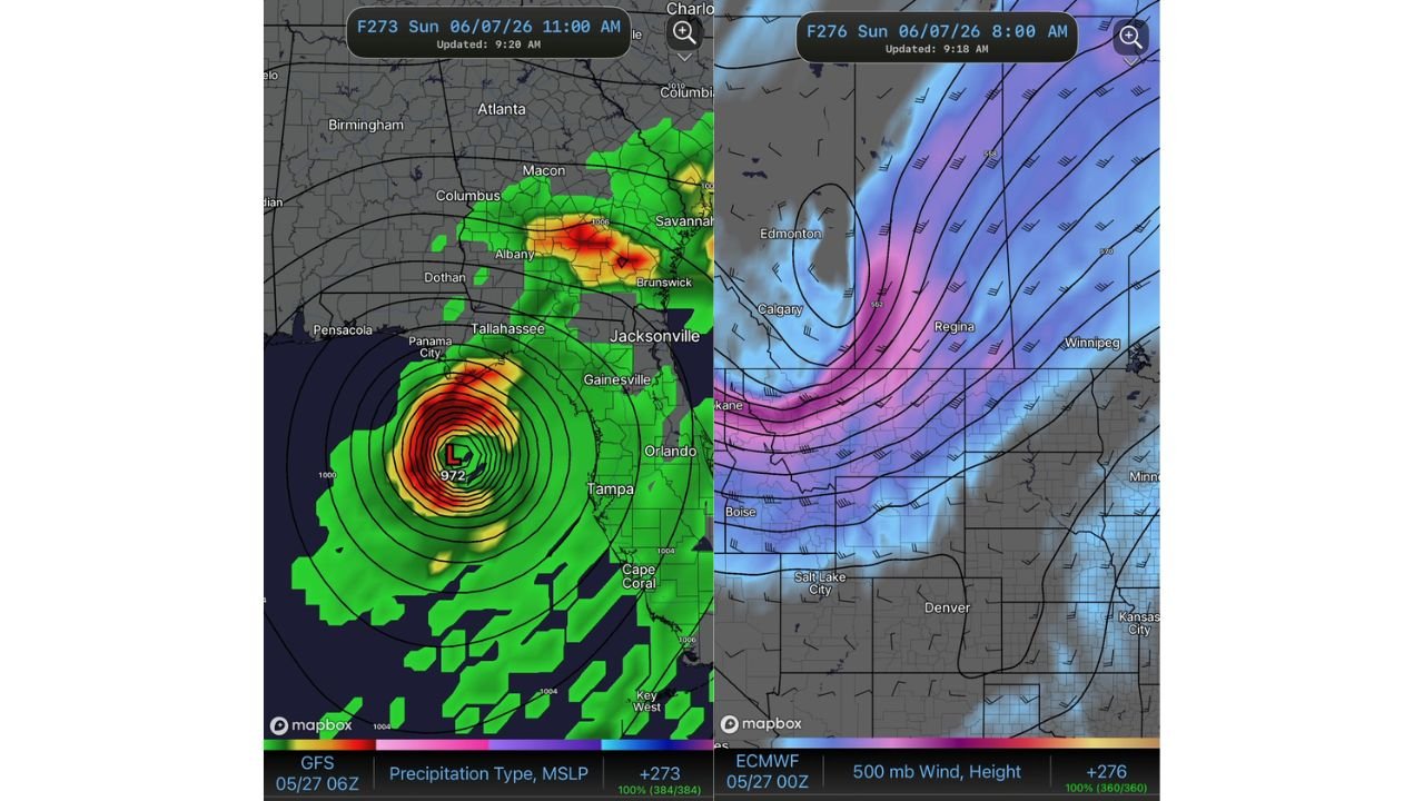
TALLAHASSEE, FLORIDA — The GFS model initialized at 06z May 27, 2026 is depicting a significant and tightly wound low pressure system with a 972 mb central pressure in the Gulf of Mexico in its F273 forecast frame valid Sunday June 7, 2026 at 11:00 AM, with the system positioned near the Gulf Coast and threatening the Panama City, Tallahassee, and broader Florida Panhandle and Big Bend region — though this remains a long-range single model signal requiring significant caution in interpretation.
GFS Depicts 972 MB Closed Low Near Florida Panhandle and Gulf Coast on June 7
The GFS F273 frame shows a deeply organized closed low pressure center marked at 972 mb sitting in the northeastern Gulf of Mexico near the Florida Panhandle coastline, with tightly packed isobars surrounding the circulation center indicating a well-developed and potentially dangerous system in this particular model solution. The precipitation type and MSLP map shows intense red and orange rainfall returns concentrated directly around the circulation center, with broad green precipitation shading extending across the Florida Panhandle, southern Georgia, and northeast Florida toward Jacksonville and Savannah.
Atlanta, Columbus, Albany, and the broader Georgia corridor all fall within the outer green precipitation footprint of this depicted system, suggesting a wide-reaching rainfall and wind impact zone if this solution were to verify.
ECMWF 500 MB Pattern Shows Deep Trough Over the Northwest Driving June Pattern
The second image showing the ECMWF 500 mb wind and height analysis for the same June 7 timeframe valid at 8:00 AM reveals the large-scale upper atmospheric driver behind the GFS Gulf system solution. A deep trough with 552 dm heights is depicted across the Canadian prairies near Regina and Calgary, with strong upper-level winds shown across the Pacific Northwest through Spokane and Boise southward toward Salt Lake City and Denver.
This upper-level pattern would theoretically provide the steering flow and atmospheric support necessary for a Gulf system to organize and track toward the Florida Panhandle region in the timeframe depicted by the GFS, lending some meteorological context to the model output even while the solution itself remains unconfirmed.
Long Range Signal Requires Caution as June 7 Remains Over 10 Days Away
At a forecast range of over 10 days from the model initialization date of May 27, this GFS solution carries extremely high uncertainty and should not be treated as a reliable or confirmed forecast. Long-range tropical and subtropical development signals at this range routinely fail to verify and the GFS has already been noted as an outlier on recent runs.
Residents across the Florida Panhandle and Gulf Coast should monitor forecast updates over the coming days as the June 7 timeframe comes into sharper focus across multiple model solutions.
Stay with GordonRamsayClub.com for the latest updates.

Leave a Reply