
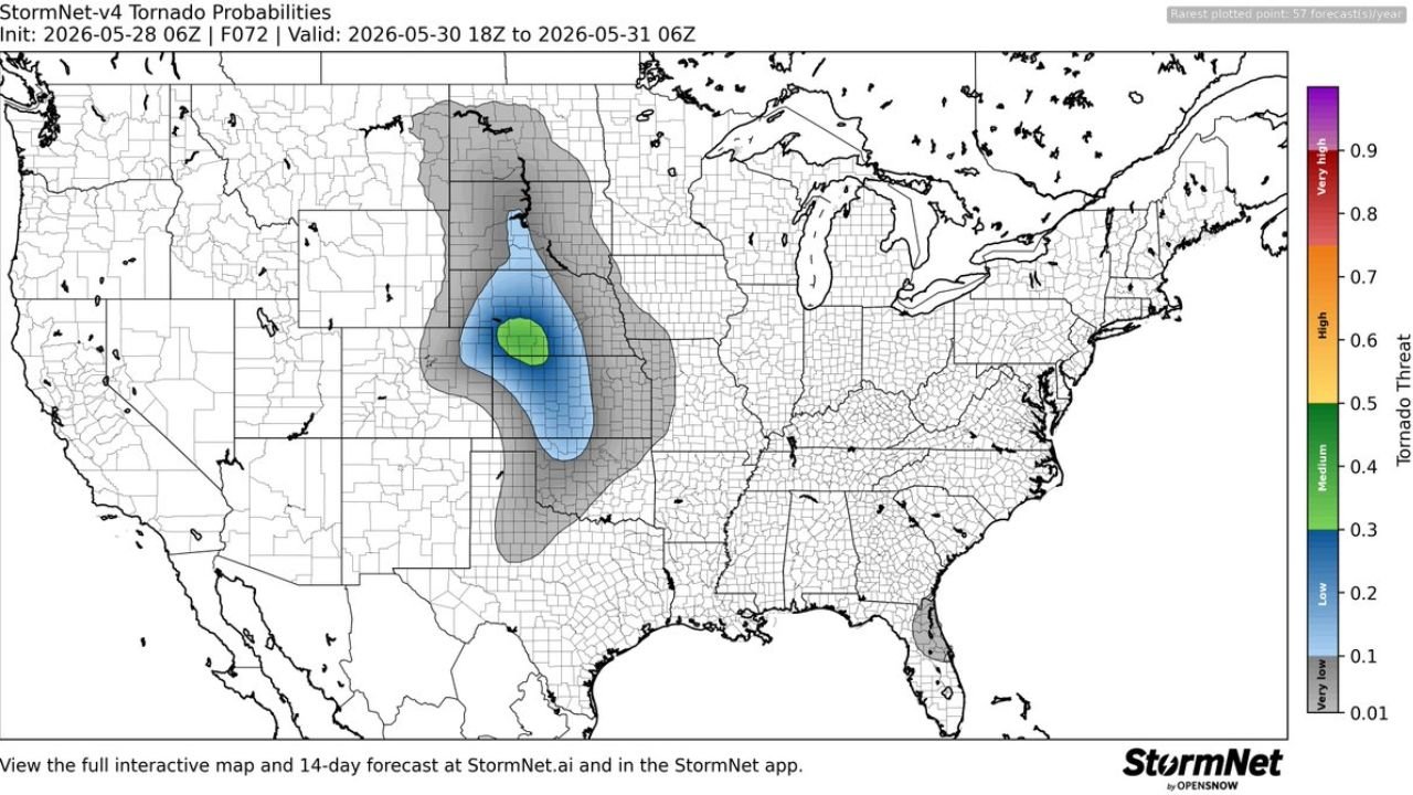
WICHITA, KANSAS — The StormNet-v4 Tornado Probability model initialized at 06z on May 28, 2026 is detecting an elevated tornado threat across a concentrated zone in the central plains for Saturday May 30, 2026, with the F072 forecast frame valid from 18z May 30 through 06z May 31 showing a medium-level tornado threat probability centered over Kansas and the surrounding region.
StormNet Model Shows Medium Tornado Threat in Green Core Over Central Kansas Corridor
The StormNet-v4 output for Saturday May 30 shows a well-defined green shading core representing a medium tornado threat probability in the 0.4 to 0.5 range on the model’s threat scale, concentrated over a focused zone in central Kansas. This green medium threat designation sits above the surrounding blue low threat zone and represents a meaningful and elevated probability of tornado development relative to climatological norms for this date and location.
The tight and well-defined nature of the green core on the map suggests the StormNet model is identifying a specific atmospheric setup favorable for tornado development across this central Kansas corridor during the Saturday afternoon and evening hours covered by the valid time window.
Broader Low Tornado Threat in Blue Extends Across Nebraska, Colorado and Oklahoma
Surrounding the medium threat core, a broader blue zone indicating a low tornado threat probability in the 0.2 to 0.3 range extends across a much wider area of the central plains. This broader blue threat footprint covers portions of Nebraska, Colorado, Kansas, Oklahoma, and potentially into Missouri, reflecting a more diffuse but still elevated tornado environment across the broader southern and central plains region on Saturday.
An additional gray very low threat zone extends even further outward across the northern plains and into the upper Midwest, including portions of the Dakotas and Montana, keeping a wide multi-state area within at least a marginal tornado awareness zone for the Saturday timeframe.
Forecast Initialized Wednesday Night With Updates Expected as Saturday Approaches
This StormNet forecast was initialized on Wednesday night May 28, 2026 and represents an early signal at the 72-hour range. Tornado forecasts at this lead time carry meaningful uncertainty and residents across the central Kansas corridor and surrounding plains states should monitor updated forecasts from the Storm Prediction Center and local NWS offices as Saturday approaches and the atmospheric setup comes into sharper focus.
Stay with GordonRamsayClub.com for the latest updates.

Leave a Reply