
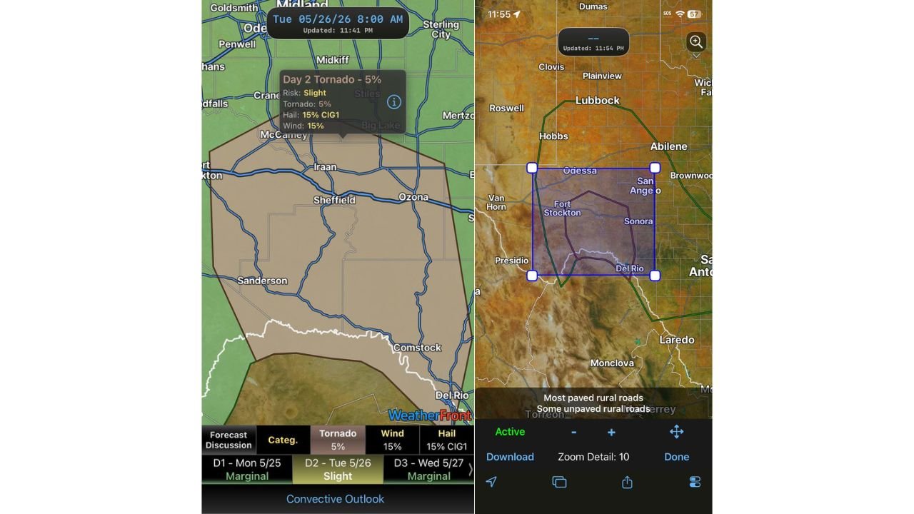
MIDLAND, TEXAS — A Slight Risk of severe weather with a 5 percent tornado probability is in place across a large stretch of West Texas today Tuesday May 26, 2026, covering a remote and sparsely connected region where road networks are thin and cell phone signal is unreliable in many locations, particularly the farther south you travel into the risk zone.
Day 2 Slight Risk Covers Midland, Sheffield, Ozona and Del Rio Corridor
The WeatherFront Convective Outlook for Tuesday May 26, 2026, updated at 11:41 PM, shows a Day 2 Slight Risk zone covering a broad swath of West Texas stretching from the Midland and McCamey area in the north down through Sheffield, Iraan, Ozona, Sanderson, Comstock, and Del Rio in the south.
The outlook parameters within the Slight Risk zone list a 5 percent tornado probability, 15 percent hail probability with a significant hail tag, and 15 percent damaging wind probability, making all three primary severe weather hazards active across this corridor today.
Sparse Road Network and Sketchy Cell Signal Make This Risk Zone Uniquely Dangerous
What makes today’s 5 percent tornado risk zone particularly concerning is the extremely remote nature of the impacted geography. Forecasters have specifically flagged that the risk area has a rather sparse road network, and cell phone signal is sketchy in many spots across the zone — especially the farther south you go toward the Del Rio and Comstock areas.
Residents, travelers, and storm chasers operating in this region are being urged to download offline maps before heading out, as low-data and no-data situations are a realistic possibility in many parts of this West Texas severe weather zone today.
Broader Lubbock to San Angelo Corridor Also Within Convective Outlook Boundaries
The third image showing the broader convective outlook area places the severe risk zone within a wider boundary stretching from near Lubbock and Hobbs in the north down through Odessa, Fort Stockton, San Angelo, Sonora, and Del Rio. This larger green outlined zone encompasses a significant portion of West and Southwest Texas within the overall convective threat area for today.
Anyone in or traveling through West Texas today should have offline navigation ready, stay weather-aware throughout the afternoon and evening, and have a clear shelter plan before venturing into the remote southern portions of the risk zone.
Stay with GordonRamsayClub.com for the latest updates.

Leave a Reply