
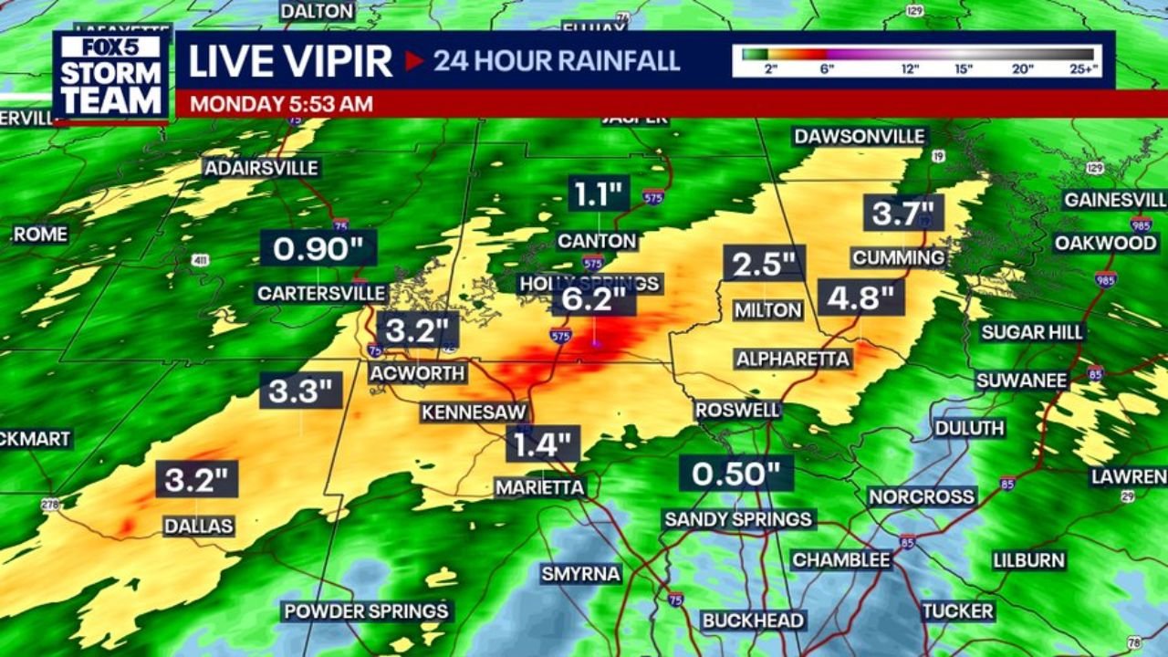
WOODSTOCK, GEORGIA — Much needed rainfall drenched the North Metro Atlanta area yesterday afternoon and evening, with FOX 5 Live Vipir radar estimates showing the heaviest totals concentrated along Highway 92 in Woodstock, where over 6 inches of rain fell in a single event, making it the clear winner across the entire metro rainfall map.
Highway 92 Woodstock Corridor Records 6.2 Inches as the Highest Total on the Map
The FOX 5 Storm Team Live Vipir 24-hour rainfall map captured at 5:53 AM Monday shows a peak value of 6.2 inches centered in the Holly Springs and Woodstock area along the Highway 92 corridor. The deep red and orange core on the radar mosaic is tightly concentrated in this zone, indicating an intense and localized rainfall footprint that significantly outpaced surrounding areas.
This level of rainfall in a single afternoon and evening event represents a substantial soaking for an area that needed the moisture, though the intensity of the core totals also raised the potential for localized flooding in low-lying areas near the storm’s heaviest bands.
Milton and Cumming See 4.8 and 3.7 Inches Across Forsyth County
Moving east and northeast from the Woodstock core, rainfall totals remained impressive. Milton recorded 4.8 inches and Cumming picked up 3.7 inches, keeping Forsyth County well within the heavier end of the rainfall distribution from yesterday’s event.
Canton recorded 2.5 inches and Dawsonville area picked up totals in the upper range as well, with the green and yellow shading on the Live Vipir map showing a broad swath of elevated rainfall stretching across the northern suburbs from west to east.
Acworth, Dallas and Cartersville Round Out Solid Totals Across Cobb and Bartow Counties
To the southwest of the heaviest core, Acworth recorded 3.2 inches, Dallas came in at 3.2 inches, and the Cartersville area picked up 0.90 inches, showing a clear gradient in rainfall totals as distance increased from the Woodstock bullseye.
Kennesaw recorded 1.4 inches and Marietta came in at 1.4 inches as well, while Sandy Springs and areas further south saw lighter totals ranging from 0.50 inches downward, reflecting how tightly focused the heaviest rainfall remained across the northern corridor.
Stay with GordonRamsayClub.com for the latest updates.

Leave a Reply