
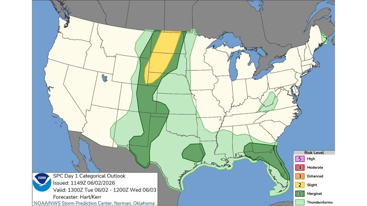
BISMARCK, NORTH DAKOTA — The Storm Prediction Center Day 1 Categorical Outlook issued at 11:49Z on June 2, 2026 and valid through 12:00Z June 3 is highlighting a multi-zone severe weather threat across the northern Plains, central and southern High Plains, and from southern Georgia into northern and eastern Florida, with large hail, severe wind gusts, and a couple of tornadoes all possible this afternoon and evening.
SPC Slight Risk Centered on Northern Plains with Large Hail and Tornado Threat
The primary and most significant risk zone on today’s SPC outlook is a Slight Risk Level 2 of 5 concentrated across the northern Plains covering North Dakota, South Dakota, and into Nebraska. This zone is surrounded by a broader Marginal Risk area stretching from Montana and Wyoming southward through Kansas and Missouri. Thunderstorms with large hail, severe wind gusts, and potentially a couple of tornadoes are expected across this Slight Risk corridor this afternoon and evening, making it the most dangerous zone in today’s multi-threat setup across the United States.
Central and Southern High Plains Facing Strong Wind Gusts and Marginal Hail
Across the central and southern High Plains, a separate Marginal Risk zone extends from Kansas southward through Oklahoma and into Texas. Strong wind gusts and marginal hail will be possible across this corridor during the afternoon and evening hours today. While this zone does not carry the tornado threat present in the northern Plains Slight Risk area, the wind and hail hazards are still significant enough to warrant close monitoring for residents across western Kansas, Oklahoma, and the Texas Panhandle region throughout Tuesday.
Southern Georgia and Northern Florida Under Marginal Risk for Severe Wind Gusts
A third separate area of concern sits across southern Georgia and into northern and eastern Florida, where a Marginal Risk zone highlights the potential for a few severe wind gusts during Tuesday’s storm activity. This southeastern zone is driven by frontal line interaction and sea breeze dynamics, with storm coverage expected along the Florida east coast and into the southern Georgia corridor through the afternoon hours consistent with the broader storm pattern affecting the Southeast today.
Residents Across All Three Threat Zones Should Stay Weather Alert Today
With active severe weather threats simultaneously targeting the northern Plains, the High Plains, and the Georgia to Florida corridor, residents across North Dakota, South Dakota, Nebraska, Kansas, Oklahoma, southern Georgia, and northern Florida should remain closely connected to local NWS forecasts and be prepared to take shelter quickly if warnings are issued in their area today.
Stay with GordonRamsayClub.com for the latest updates.

Leave a Reply