
MINNEAPOLIS, MINNESOTA — A deeply concerning soil moisture crisis is visible across the Central Plains, Upper Midwest, and Great Lakes region as of May 28, 2026, with NASA Sport LIS index soil moisture percentile data and USDA agriculture soil moisture mapping both painting an alarming picture of critically dry conditions stretching from the Dakotas through Minnesota, Iowa, Nebraska, and into Illinois and Indiana.
NASA Sport LIS Soil Moisture Data Shows Critically Dry Conditions Across Wide Region
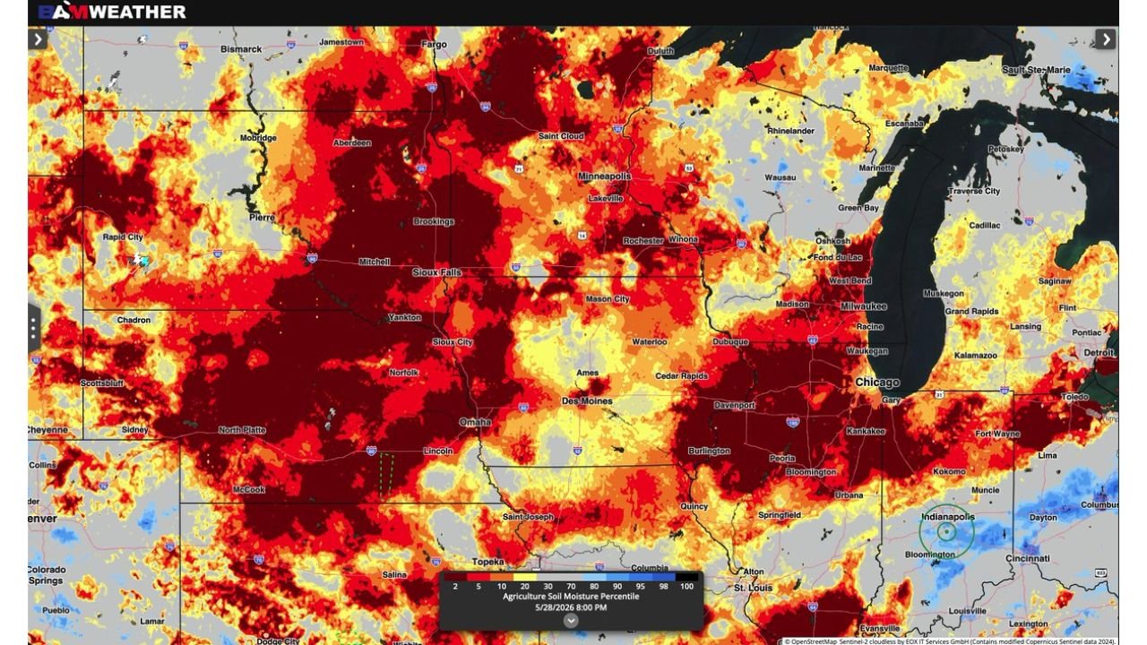
The BAM Weather NASA Sport LIS index soil moisture percentile map valid May 28, 2026 at 8:00 PM shows deep red and dark red soil moisture percentile values of 2 to 10 percent covering an enormous geographic footprint. The most critically dry zones are concentrated across the Dakotas from Bismarck and Pierre through Rapid City, across Minnesota from Minneapolis through Saint Cloud and Duluth, across Iowa from Des Moines and Sioux Falls through Cedar Rapids and Waterloo, and across Nebraska from Omaha and Lincoln through Norfolk and North Platte. These dark red values indicate soil moisture percentiles in the lowest 2 to 5 percent of historical records, representing some of the most extreme agricultural drought stress conditions possible.
Drought Footprint Stretches From Dakotas Through Illinois and Indiana
The soil moisture crisis visible on the NASA LIS data extends well beyond the core red zone. Yellow and orange values indicating below normal to significantly below normal soil moisture cover an even broader area stretching from Wyoming and Colorado through Kansas and Missouri and eastward into Illinois near Chicago, Peoria, and Springfield and into Indiana near Fort Wayne and Indianapolis. The sheer geographic scale of the below normal soil moisture footprint across the central United States raises serious concerns for crop development heading into the heart of the 2026 growing season.
USDA and NASA Data Both Confirming the Severity of Current Soil Moisture Deficit
Both the USDA agriculture soil moisture percentile mapping and the NASA Sport LIS index are independently confirming the severity of the current soil moisture deficit across the region. Forecasters note the two datasets are closely aligned in their depiction of critically low soil moisture, leaving little uncertainty about the genuine nature and depth of the agricultural drought stress currently affecting the Central Plains and Upper Midwest heading into June 2026.
Agricultural Interests Across the Corn and Soybean Belt Face Critical Period Ahead
With soil moisture percentiles sitting at critically low levels across the heart of the American corn and soybean belt, the coming weeks of precipitation outcomes will be absolutely decisive for the 2026 crop season. Farmers and agricultural interests across Minnesota, Iowa, Nebraska, Illinois, and Indiana are urged to monitor updated soil moisture and precipitation forecasts closely as the critical early June growing window progresses.
Stay with GordonRamsayClub.com for the latest updates.

Leave a Reply