
CHICAGO, ILLINOIS — The HRRR model is painting a volatile tornado environment across northern Illinois and southern Wisconsin Thursday afternoon, with Significant Tornado Parameter values spiking dramatically near the warm front in a zone covering Madison, Janesville, Milwaukee, Rockford, and Chicago at 5PM Thursday June 11.
HRRR STP Values Explode Near the Warm Front Thursday Afternoon
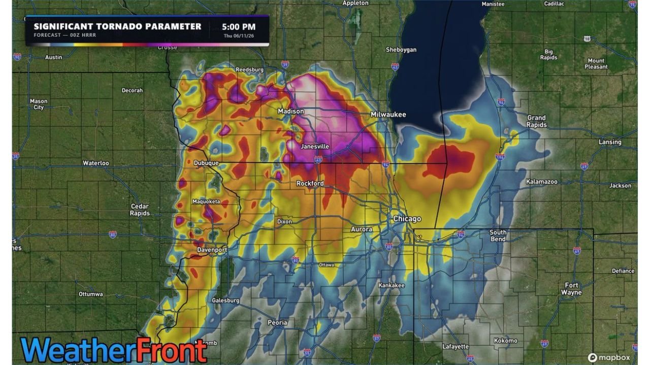
The 00z HRRR Significant Tornado Parameter forecast valid 5PM Thursday shows intense overlapping tornado ingredients concentrated in a tight corridor centered on Madison, Janesville, and the Rockford to Chicago axis. Purple and magenta shading dominates the core zone, indicating the highest concentration of tornado-favorable ingredients on the map.
While the STP graphic is not a direct probability of tornado occurrence, it illustrates how well the individual ingredients needed for significant tornadoes are stacking up in a small geographic area near the warm front Thursday afternoon. Forecasters note the overlap is exceptionally tight for this event.
Strong Tornadoes Possible if Storms Can Organize
The critical caveat to Thursday’s setup is storm organization. If a storm can develop and take advantage of the volatile environment near the warm front, strong tornadoes are explicitly in the cards for northern Illinois and southern Wisconsin according to forecasters analyzing this data.
The warm front itself is the focus area, where low-level wind shear, moisture, and instability will converge most favorably during the late afternoon hours Thursday.
Broad Zone of Elevated STP Extends Across the Region
Elevated STP values extend well beyond the core, with orange and red shading covering Dubuque, Davenport, Maquoketa, Dixon, Aurora, and pushing into South Bend and Kalamazoo. The broad footprint of elevated values means the tornado-favorable environment is not confined to a narrow corridor Thursday afternoon.
Residents across northern Illinois and southern Wisconsin should treat Thursday as a high-end severe weather day, keep emergency alerts active, and be ready to shelter immediately if tornado warnings are issued during the afternoon and evening hours.
Stay with GordonRamsayClub.com for the latest updates.

Leave a Reply