
CEDAR RAPIDS, IOWA — Wednesday is shaping up to be the most significant tornado day the Midwest has seen in some time, with forecasters identifying Cedar Rapids, Rochester, and Madison as the highest probability corridor for tornado activity today as discrete supercells and a thunderstorm line both carry tornado potential across the region.
Highest Tornado Probability Centered on Cedar Rapids and Rochester
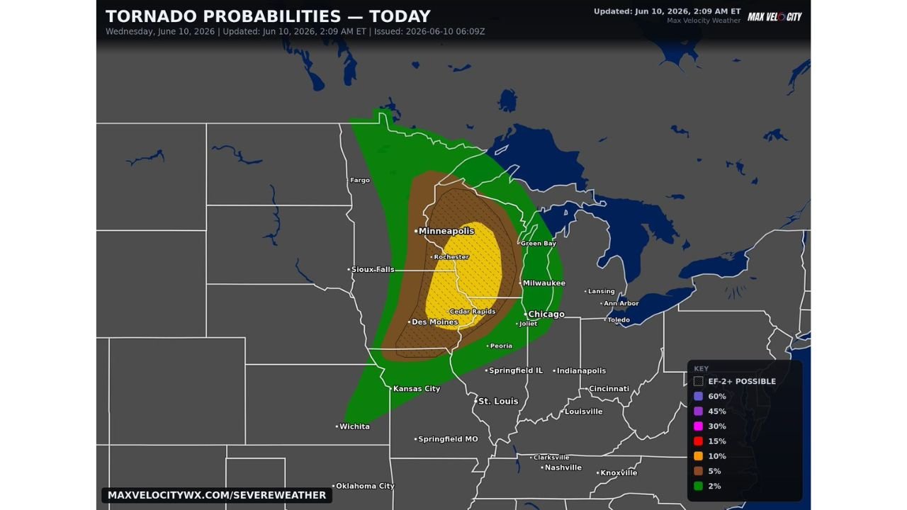
The Max Velocity tornado probability map valid Wednesday June 10 places a 30 percent tornado probability zone in yellow centered directly over Cedar Rapids, Des Moines, Rochester, and Minneapolis. This is the highest probability corridor on today’s map and represents a meaningful standalone tornado threat for the upper Midwest.
EF-2 plus tornado hatching is overlaid across this same zone, confirming that significant tornadoes are explicitly possible within the highest probability area. Both discrete supercells and a line of thunderstorms are expected to contribute tornado potential throughout the day.
EF-2 Plus Tornadoes Possible From Northern Missouri to Northern Wisconsin
The EF-2 plus tornado threat extends well beyond the highest probability core, covering a broad corridor from northern Missouri northward through Iowa, Minnesota, and into northern Wisconsin. Several tornadoes are considered likely across this zone from the combination of supercell and line-embedded storm modes.
A 10 percent tornado probability in orange surrounds the yellow core, covering Sioux Falls, Fargo, Milwaukee, Chicago, and Joliet. The 5 percent brown zone pushes the threat further outward across Kansas City, St. Louis, Peoria, Springfield, and Green Bay.
First Significant Tornado Day for the Midwest This Season
Forecasters are noting that it has been a considerable stretch since the Midwest has seen a setup of this caliber for significant tornado potential. Wednesday’s combination of discrete supercells and a squall line producing EF-2 plus capable tornadoes across a multi-state corridor qualifies as a high-end tornado day for the region.
Residents across Iowa, Minnesota, Wisconsin, and northern Missouri should have tornado sheltering plans ready, keep wireless emergency alerts active, and avoid unnecessary travel during peak storm hours today.
Stay with GordonRamsayClub.com for the latest updates.

Leave a Reply