
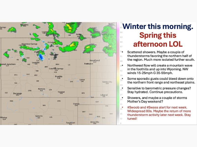
DENVER AND FRONT RANGE, COLORADO — A dramatic weather contrast is unfolding across Denver and the Front Range on Thursday, May 7, 2026, with frigid morning temperatures giving way to a rapid warmup into the 60s and 70s by afternoon as northwest flow aloft scours out the cold airmass quickly. However, that same northwest flow will trigger a mountain wave in the foothills and across the Divide and into southeast Wyoming, bringing gusty northwest winds of 15 to 25 mph with gusts reaching 35 to 55 mph across notoriously blowy spots throughout the day.
Mountain Wave and Gusty Winds Today
The northwest flow aloft responsible for warming temperatures across the Denver and Front Range area will simultaneously generate a mountain wave across the foothills, the Divide, and into southeast Wyoming. Northwest winds of 15 to 25 mph are expected across the region with gusts reaching 35 to 55 mph at the most exposed and notoriously windy locations along the Front Range corridor.
Some sporadic gusts could also bleed down onto the northern Front Range and northeast plains, spreading the wind hazard beyond just the mountain communities and into the broader region throughout Thursday.
Scattered Showers and Thunderstorms Possible
Alongside the gusty winds, a few scattered hit or miss showers and thunderstorms are favoring the northern half of the region today, moving from northwest to southeast. The storms are not expected to produce significant rainfall, but gusty winds, spicy cloud formations, and lightning are all possible and could create disruptions for air travel across the region during the afternoon hours.
Communities further south will see much more isolated storm activity compared to the northern half of the Front Range where coverage will be more scattered.
Weekend and Next Week Outlook
Friday brings temperatures about 3 to 5 degrees warmer with showers becoming much more isolated across the region. Mother’s Day weekend is shaping up to be a pleasant stretch with widespread 70s expected and mid 80s developing across southern Colorado, Kansas, and the western slope.
Sunday could bring a few more showers and storms for Mother’s Day itself, though confidence in that scenario remains low at this stage. Next week brings widespread 80s expected for the majority of the week, with the possibility of more significant and spicy thunderstorm activity returning for the latter part of next week as the pattern evolves. Stay with GordonRamsayClub.com for the latest updates.

Leave a Reply