
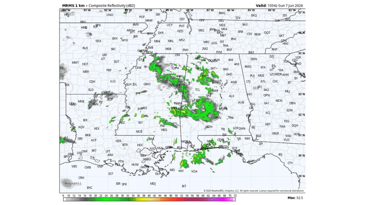
BIRMINGHAM, ALABAMA — Areas of mostly light rain are moving across Alabama this Sunday morning June 7, 2026, as MRMS 1km composite reflectivity valid 10:54Z Sunday June 7 shows widespread green radar returns covering central and northern Alabama from Tupelo through Birmingham, Montgomery, and surrounding communities, with tropical moisture levels increasing across the state and afternoon highs expected in the low 80s today.
Light Rain and Scattered Thunderstorms Moving Across Alabama This Morning
MRMS 1km radar valid 10:54Z Sunday June 7, 2026 shows an active precipitation pattern across central and northern Alabama, with moderate green returns and isolated yellow cores indicating heavier rainfall concentrated across the Birmingham, Tuscaloosa, and Montgomery corridors. Rain coverage is also noted across portions of Mississippi near Tupelo and southward toward the Gulf Coast, consistent with the broad tropical moisture surge that has increased humidity and precipitation coverage across the entire Alabama region this morning. Today will not be an all-day rain event and it will not rain everywhere, but scattered showers and thunderstorms will remain possible at various times through the day.
Week Ahead Features Daily Scattered Showers with Highest Coverage Monday and Tuesday
The week ahead across Alabama will maintain a daily chance of scattered showers and thunderstorms, which is typical and routine summer weather for the state. The highest storm coverage during the early part of the week will likely be concentrated over the northern half of Alabama on Monday and Tuesday, with communities from Huntsville and Florence through Birmingham and Gadsden seeing the most active shower and storm coverage during those two days. Afternoon highs during the early week period will remain in the low to mid 80s as moisture keeps temperatures from climbing significantly.
Upper Ridge Builds Late Week Pushing Highs to 90 Degrees Thursday and Friday
An upper-level ridge is expected to build across the region during the latter half of the week, suppressing shower activity and allowing afternoon temperatures to climb significantly. By Thursday and Friday, afternoon highs are expected to reach at or just over 90 degrees for many Alabama communities as the ridge strengthens and limits cloud cover and rainfall across the state. The combination of 90-degree heat and elevated humidity will create uncomfortable heat index values across Alabama heading into the June 12 to 13 period.
Weekend of June 13 to 14 Looks Typical for June with Afternoon Storm Chances
Looking ahead to the weekend of June 13 to 14, conditions appear to feature typical June weather for Alabama with partly sunny skies and the chance of an afternoon or evening shower or storm in scattered locations. No significant severe weather setups are anticipated for the June 13 to 14 weekend at this time, offering a relatively routine early summer weather pattern for residents across the state.
Stay with GordonRamsayClub.com for the latest updates.

Leave a Reply